I've written about the transition movement before, somewhat skeptically. I'm still skeptical about the movement itself, but I agree that something needs to be done. Here's one alternative that we could wind up with, if we don't manage things right: the return of slavery.
In a Guardian article in February, Jean-François Mouhot observed that the rise of fossil fuels overlapped with the decline of slavery, and in some ways enabled it. He wasn't the first; in fact, he mentions reading it in "a book on climate change." I just listened to an intense exploration of the human history of slavery by Dan Carlin. His dramatic delivery gets a little carried away at times, but this episode is worth two dollars and an hour of your time. (Be warned, there are graphic descriptions of the abuses of slavery.) One of his main points is that to their owners, slaves were the original "labor-saving devices."
Mouhot and others compare the morality of slavery with the morality of fossil fuel use, observing that climate change and other effects of pollution cause a lot of death and suffering around the world. He also asks whether we can borrow some tactics from the abolitionists in our own campaign to reduce or even abolish fossil fuel use. To be honest, I'm skeptical: if the availability of "labor-saving devices" running on fossil fuels gave us the economic leeway to abolish slavery, what is giving us the economic leeway to abolish fossil fuels?
But it gets worse. As fossil fuels get harder and more expensive to extract from the ground, it will get more and more expensive to run the labor-saving devices. We will have two options: work harder or get someone else to do it.
I haven't read James Howard Kunstler's World Made by Hand books, but as I understand them, part of the story involves the reestablishment of some form of forced labor in the disorder following an economic collapse brought on by an energy crisis. If such a thing comes to pass, some people will be tempted to go beyond this kind of serfdom to outright slavery.
I don't think that slavery is inevitable, but I do think it's a danger that we need to try and protect ourselves against. Some might argue that our constitution is protection enough. Others might say that our values have changed enough that we can never go back. Do you believe that?
Wednesday, August 29, 2012

Tuesday, August 28, 2012
How many Jakriborgs is that?
Earlier this year, the Small Streets Blog introduced us to the planned community of Jakriborg, founded in 1990 on 12.5 acres of farmland between the cities of Malmö and Lund in southern Sweden, next to a frequent commuter rail line and a bus stop. It has "parking on the outside," as planned for the Piscataquis Village Project in Maine, but there are very few - I count less than a hundred spaces for a population of over 500 families.
(There's also a disturbing lack of people on the street in most of the photos you see of Jakriborg. Maybe the photos were taken in the height of winter, but I always thought the Swedes were out getting fresh air in the height of winter.)
Building on my post criticizing park-and-rides, the Small Streets crew imagined replacing part of a park-and-ride with a dense, walkable village like Jakriborg or the Czech town of Telč. They astutely observe that if you build at Jakriborg densities, you get more riders than if you used the land for a park-and-ride, and these riders all live within walking distance of the station.
Phil LaCombe from Small Streets takes the example of the park-and-ride in Greenbelt, Maryland, which holds 3,399 parking spaces. Those 37 acres can fit almost three Jakriborgs, which can house over 4,000 people in total, including children. That's a net gain of 701 people over the park-and-ride. If the 701 additional people are children they probably wouldn't pay taxes, but their parents would pay taxes and shop at the local stores.
Inspired by Phil, whenever I see a large parking lot near a train station, I think to myself, "How many Jakriborgs is that?" The Metro-North parking lot at Croton-Harmon is 1.3 Jakriborgs, I believe. The parking lot planned for the North Tenafly station on the Northern Branch is 0.68 Jakriborgs.
I thought of this today when I read that the New Jersey borough of Dunellen has been accepted into the state's Transit Village incentive program. Acceptance is based on a detailed application where the municipality specifies land within a quarter mile of a transit station that can be developed into walkable housing and shops.
It would be really nice if the state put all of its accepted applications up on its website so that we could see what's being planned. We could then monitor the progress of the various municipalities and see how much they live up the the hype. No such luck.
Mayor Robert Seader, however, specifically mentioned the 19-acre Art Color site, a printing plant right next to the train station that was abandoned in 1968. That's a Jakriborg and a half right there.

All across New Jersey I've seen shitty "condo" developments where you can't go anywhere without walking across endless parking lots, like this garbage across the tracks from the planned North Tenafly parking lot. That's not transit-oriented, and its walk appeal is zero. With no train service I can kind of understand them building these parking lots, but otherwise no. I hope that whatever goes in the old Art Color site is more like Jakriborg and less like Daibes Park Residences.
Another quick note: Dunellen was originally formed from the township of Piscataway. Piscataway, in turn, was founded by Quakers and Baptists who didn't want to live under the Puritans along the Piscataquis River in Maine. So if Dunellen builds a Jakriborg-type carfree village with small streets on the Art Color site, it could end up being a Piscataway Village Project. And as I said, Really Narrow Streets need good trains. Of course, then it would help if the Raritan Valley Line were as frequent a train as the line that serves Jakriborg.
Monday, August 27, 2012
Who's getting out of the way?
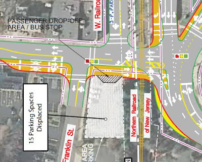
When you look at the maps for the "parking and traffic mitigations" near the proposed stations along the Northern Branch (PDF), you'll see little bus bays like this one in Tenafly:
Or these in Leonia:

You might think, "Oh, how nice! Infrastructure for buses." In fact, I once saw on the web where these bus bays were presented to bus riders as one way to improve their commute. (I wish I could find it now!) But just because someone designs infrastructure for you doesn't mean that the goal is to help you. It's like that old science fiction story, "To Serve Man."
Bus bays in fact slow down buses quite a bit. It's a very similar situation to a street with curb parking everywhere except the bus stop. If you've been on a bus trying to pull out from one of those stops into rush hour traffic, you know exactly what's wrong with bus bays. The only places where I think they're at all warranted are stops on high-speed roads like Route 4 or Route 17 in New Jersey, where there's a real chance that some texting driver could rear-end the bus.
These proposed bus bays in Leonia and Teaneck are not that kind of traffic. They have no protective purpose; their only reason for being built is so that the buses can get out of the way of private cars.
Bus bays do so much to slow buses down that where bus riders have some political power, the government builds the opposite: bus bulbs. They allow buses to remain in the flow of traffic while picking up passengers in a street where there is also curbside parking, like First Avenue in Manhattan.
It's a similar situation with pedestrian overpasses and underpasses. People propose them like they're God's Gift to Pedestrians, but they're really about getting pedestrians out of the way of cars.
That's why when someone proposes a new kind of infrastructure that you haven't heard of, especially one that separates uses, you should ask yourself who's getting out of the way. Who's being inconvenienced? Very rarely, the safety justifies the inconvenience. Examples include the bus park-and-ride on Route 17 in Ridgewood, and pedestrian overpasses across bona fide high speed limited-access highways, like the Long Island Expressway. In everything else, as Ottawa planners know, transit users and pedestrians should come first.
Saturday, August 25, 2012
Gentrification complete?
After investigating the definitions of "suburb," I was thinking about Feargus O'Sullivan's description of "urban" London. There were three simple characteristics: proximity to the center of London, density and noise. All the other "urban" characteristics were either signs of (a) gentrification (coffee bars; vintage stores; sidewalk cafes; hipster bicycle culture; independent designer boutiques; high-rise, open-plan apartments) or (b) poverty (subsidized housing).
Here in New York City, we have the same signs of gentrification, but poor people can and do live in privately owned, usually rent-stabilized, apartments throughout the city. We have many dense, noisy neighborhoods that are not particularly gentrified. O'Sullivan seems to equate "urban" with gentrified, and that makes me wonder whether there are any neighborhoods of London left ungentrified.
In New York you can certainly find hipster coffee bars in most neighborhoods of Manhattan, Brownstone Brooklyn and Western Queens, but there are a lot of dense, transit-accessible neighborhoods that still don't have them. Last I checked that included Crown Heights and Flatbush, as well as Sunset Park and most of Corona in Queens. Most of Jersey City, Elizabeth and Newark are pretty low on the vintage stores, as are western Yonkers and southern Mount Vernon - though of course they have thrift stores. And of course, most of the Bronx between Fieldston and the Bronx River is dense urban development, and I'm not sure there's even a coffee bar in Riverdale. That means that probably half of the urban area of New York is still ungentrified.
I haven't spent that much time in London, and what time I have spent there has been in areas that have not been poor in recent memory. I didn't see any housing projects around Buckingham Palace or the Houses of Parliament, where the homes of the literal gentry have historically been. I did take a stroll through Peckham on my last visit and didn't see any gourmet cafes, but I wasn't looking that hard. So those of you who know London better: are there large gentrifying populations in every dense inner neighborhood? Are there notable exceptions?
If not, I wonder how much of it is due to the way London subsidizes its housing. Is there rent stabilization, or is it all done through "council flats"? Does that create sharper segregation?
I'll have more to say about this in the future.
Here in New York City, we have the same signs of gentrification, but poor people can and do live in privately owned, usually rent-stabilized, apartments throughout the city. We have many dense, noisy neighborhoods that are not particularly gentrified. O'Sullivan seems to equate "urban" with gentrified, and that makes me wonder whether there are any neighborhoods of London left ungentrified.
In New York you can certainly find hipster coffee bars in most neighborhoods of Manhattan, Brownstone Brooklyn and Western Queens, but there are a lot of dense, transit-accessible neighborhoods that still don't have them. Last I checked that included Crown Heights and Flatbush, as well as Sunset Park and most of Corona in Queens. Most of Jersey City, Elizabeth and Newark are pretty low on the vintage stores, as are western Yonkers and southern Mount Vernon - though of course they have thrift stores. And of course, most of the Bronx between Fieldston and the Bronx River is dense urban development, and I'm not sure there's even a coffee bar in Riverdale. That means that probably half of the urban area of New York is still ungentrified.

I haven't spent that much time in London, and what time I have spent there has been in areas that have not been poor in recent memory. I didn't see any housing projects around Buckingham Palace or the Houses of Parliament, where the homes of the literal gentry have historically been. I did take a stroll through Peckham on my last visit and didn't see any gourmet cafes, but I wasn't looking that hard. So those of you who know London better: are there large gentrifying populations in every dense inner neighborhood? Are there notable exceptions?
If not, I wonder how much of it is due to the way London subsidizes its housing. Is there rent stabilization, or is it all done through "council flats"? Does that create sharper segregation?
I'll have more to say about this in the future.
Why we shouldn't extend Metro-North on the Hudson Line
Mid Hudson News reports that Metro-North is still no longer considering extending service to northern Dutchess County. I'm not sure who was asking, but there you have it.
Many years ago, there was a proposal to extend service past Poughkeepsie, with stops in Hyde Park, Staatsburg, Rhinecliff and Tivoli. There was significant NIMBY opposition, and I was all ready to cuss out those transit haters, but the more I looked at it, the more their objections made sense.
It was the same problem I had with the Northern Branch plan, but even more so, because the planners expected almost every rider to drive and park. None of those stations have anything resembling the walkable suburban downtowns of Englewood and Tenafly.
To generate enough walk-up demand for the service, you'd essentially need to rezone the area to create a whole new Tarrytown, Irvington, Dobbs Ferry and Hastings. Which might be nice, but do we really need that development eighty miles from Manhattan?
We need to look at what our goals are, and how a Metro-North extension might serve them. If people are driving too much in Dutchess County, replacing a small number of large lots with new walkable suburbs will not make the existing residents drive less.
There are small things we could do. Extend some trains to Marist and Hyde Park, and maybe the CIA, to capture some of the student and tourist travel. But that's a relatively small segment of the market; would it be worth running ten-car trains?
The largest existing town without train service in Dutchess County is Fishkill. Emily from IRidetheHarlemLine.com thought it was funny that someone would want to ask Metro-North President Howard Permut about restoring passenger service on the Beacon/Maybrook Line that the railroad owns, but it's not such a strange question. Of all the potential Dutchess County service expansions it's the one that would have the greatest ridership. It runs through the most densely populated parts of Beacon and Fishkill.
At this point it might not be worthwhile running trains all the way to Derby, Danbury or even Brewster, but a local group has proposed a shuttle from the Beacon Station to Matteawan and Fishkill. You could also run a shuttle from Croton, timed to connect with the incoming local from Grand Central.
The State is planning to upgrade the Hudson Line to improve Amtrak service. Dutchess County could use more intercity service, and restoring service to Pittsfield through Amenia, Millerton and Chatham, perhaps run by Amtrak, would capture a significant portion of the weekend crowd that currently drives up the Taconic Parkway.
Emily actually asked Permut about service north of the current terminus in Wassaic, and he mentioned that he was involved in planning the current service. "If I remember correctly, the rail trail was already in existence to Millerton, so we would have had a huge obstacle," Permut said. "How do you de-map a rail trail? There would have been significant opposition." More proof that rail-trails are not good for transit.
Of course, my question for Permut, which Emily did not ask, was "If you could tear down one highway in the region, which one do you think would increase Metro-North ridership the most?" Dutchess County actually doesn't have many highways. There's one interstate (84), plus the Taconic Parkway. There are some relatively short limited-access sections of Routes 9, 44 and 55.
I would probably first get rid of the "Arterials" in Poughkeepsie, a horrible plan where two neighborhood avenues were turned into three-lane segments of a one-way pair, simultaneously killing both the pedestrian environment and commerce on Main Street. I'm baffled that the arrangement has lasted as long as it has, and I can only surmise that that's because no New Urbanist has ever visited Poughkeepsie. Restoring the Arterials to neighborhood streets, and restoring Main Street to east-west traffic, would make a lot more people want to live within walking distance of the train station. Green tracks trolleys on the former "Arterial" streets would bring more people to the train without driving.

All that said, if we really want to reduce driving in the metropolitan area, it's probably better to focus on other areas than Dutchess County. According to reports compiled by the EPA, Dutchess only accounts for two percent of the region's vehicle-miles traveled. Meanwhile, Nassau accounts for 8% of VMT, and Suffolk 13%. If only they had train service...
Thursday, August 23, 2012
Know your suburbs
Today Feargus O'Sullivan had a nice post in the Atlantic Cities called "Why I Moved Back to the Suburbs." The post's slug tells us (no, not like that) that an earlier title was "Why the Suburbs Have the City Beat," which is appropriate since he's talking about Desmond Dekker's old neighborhood.
There were several confused responses, many of which assumed that by "suburb" O'Sullivan was referring to a prototypical suburb like Yorktown Heights or Rio Rancho. Some, like Sarah Goodyear, assumed that it was a difference of British versus American usage, but it isn't. I've seen the same confusion among Americans; the Times has had at least three articles over the past fifteen years calling the Upper West Side "suburban."
The official definition of "suburb" is a place outside the city limits. But the city limits have changed. Neighborhoods that we would call "downtown" today, like Greenwich Village, Mayfair and the Marais, were all suburbs once. From that official perspective, O'Sullivan's "suburb" of Forest Hill is within the County of Greater London, and thus just as much an inner-city neighborhood as his old neighborhood in Hackney. Greenpoint here in New York City, which he disparages, has a similar administrative status.
The problem is that there are several features of suburbs that catch our attention more than whether they are within the city limits. We often essentialize these features and assume that all suburbs are that way. When someone says "suburb" they may actually be referring to just a few of those features, or even a single one.
To help with this confusion, I have put together this field guide to suburbs. The next time you come across a puzzling use of the term "suburb," just pull up this post and you should be able to sort things out. And the next time you're planning to write about "the suburbs" or "suburban attitudes," please do us all a favor and make it clear which features of the suburbs you're talking about.
Suburban-official: Outside the limits of a large city. By this feature, none of the neighborhoods that O'Sullivan mentions are suburban. Medway is the closest suburb to him. Official-suburbs in the New York area include Guttenberg (the most densely populated municipality in the United States) and Wyandanch (one of the poorest municipalities in New York State).
Suburban-rich: Richer than inner neighborhoods. By this feature, Forest Hill (median income £24,397) is slightly less suburban than Shoreditch (£28,028). But European cities have always had different income distributions than North American ones. In France, suburbs ("banlieue") are associated with poverty, even though there are plenty of wealthy suburbs, like Neuilly where Nicolas Sarkozy was mayor. New York has wealthy "suburbs" within the city limits like Forest Hills and Riverdale, and outside like Montclair and Chappaqua, and plenty of poor districts on both sides of the city line.
Suburban-white: Higher percentages of people of European ethnic backgrounds than inner neighborhoods. This is very typical of the United States, a result of the "white flight" of the 1960s and 1970s. Again, this is reversed in Paris. O'Sullivan's Lewisham is 56% white, while Hackney is 47% white. Notable New York-are counterexamples are Mount Vernon, home of P. Diddy, and Union City (84% Hispanic).
Suburban-bland: "There was nothing going down at all," is how Lou Reed put it. This is hard to quantify, because Jenny's parents probably thought there were lots of things going down. It's certainly clear that there are plenty of neighborhoods outside city limits with active cultural scenes (even for teenagers) and plenty of inner city neighborhoods without much going down. If your measure is funky coffee bars, there are plenty in Bergen County.
Suburban-low-density: This may be what O'Sullivan is really using, but it's all relative. Certainly, his Forest Hill is at least as dense as Greenpoint. There are some New York suburbs that have tried density, including Stamford, Scarsdale, Hackensack, and if you accept them Riverdale and Forest Hills.
Suburban-car: This is a big one for me. Of course, the newer the area the better the road infrastructure and the more parking there is. But it doesn't have to be that way: there are plenty of "streetcar suburbs" and suburbs built around commuter rail stations that are dense, walkable and hard to drive in.
There are a few other features, like Suburban-right-wing, Suburban-safe and Suburban-leafy that I'll leave as an exercise to the reader.
There were several confused responses, many of which assumed that by "suburb" O'Sullivan was referring to a prototypical suburb like Yorktown Heights or Rio Rancho. Some, like Sarah Goodyear, assumed that it was a difference of British versus American usage, but it isn't. I've seen the same confusion among Americans; the Times has had at least three articles over the past fifteen years calling the Upper West Side "suburban."

The official definition of "suburb" is a place outside the city limits. But the city limits have changed. Neighborhoods that we would call "downtown" today, like Greenwich Village, Mayfair and the Marais, were all suburbs once. From that official perspective, O'Sullivan's "suburb" of Forest Hill is within the County of Greater London, and thus just as much an inner-city neighborhood as his old neighborhood in Hackney. Greenpoint here in New York City, which he disparages, has a similar administrative status.
The problem is that there are several features of suburbs that catch our attention more than whether they are within the city limits. We often essentialize these features and assume that all suburbs are that way. When someone says "suburb" they may actually be referring to just a few of those features, or even a single one.
To help with this confusion, I have put together this field guide to suburbs. The next time you come across a puzzling use of the term "suburb," just pull up this post and you should be able to sort things out. And the next time you're planning to write about "the suburbs" or "suburban attitudes," please do us all a favor and make it clear which features of the suburbs you're talking about.
Suburban-official: Outside the limits of a large city. By this feature, none of the neighborhoods that O'Sullivan mentions are suburban. Medway is the closest suburb to him. Official-suburbs in the New York area include Guttenberg (the most densely populated municipality in the United States) and Wyandanch (one of the poorest municipalities in New York State).
Suburban-rich: Richer than inner neighborhoods. By this feature, Forest Hill (median income £24,397) is slightly less suburban than Shoreditch (£28,028). But European cities have always had different income distributions than North American ones. In France, suburbs ("banlieue") are associated with poverty, even though there are plenty of wealthy suburbs, like Neuilly where Nicolas Sarkozy was mayor. New York has wealthy "suburbs" within the city limits like Forest Hills and Riverdale, and outside like Montclair and Chappaqua, and plenty of poor districts on both sides of the city line.
Suburban-white: Higher percentages of people of European ethnic backgrounds than inner neighborhoods. This is very typical of the United States, a result of the "white flight" of the 1960s and 1970s. Again, this is reversed in Paris. O'Sullivan's Lewisham is 56% white, while Hackney is 47% white. Notable New York-are counterexamples are Mount Vernon, home of P. Diddy, and Union City (84% Hispanic).
Suburban-bland: "There was nothing going down at all," is how Lou Reed put it. This is hard to quantify, because Jenny's parents probably thought there were lots of things going down. It's certainly clear that there are plenty of neighborhoods outside city limits with active cultural scenes (even for teenagers) and plenty of inner city neighborhoods without much going down. If your measure is funky coffee bars, there are plenty in Bergen County.
Suburban-low-density: This may be what O'Sullivan is really using, but it's all relative. Certainly, his Forest Hill is at least as dense as Greenpoint. There are some New York suburbs that have tried density, including Stamford, Scarsdale, Hackensack, and if you accept them Riverdale and Forest Hills.
Suburban-car: This is a big one for me. Of course, the newer the area the better the road infrastructure and the more parking there is. But it doesn't have to be that way: there are plenty of "streetcar suburbs" and suburbs built around commuter rail stations that are dense, walkable and hard to drive in.
There are a few other features, like Suburban-right-wing, Suburban-safe and Suburban-leafy that I'll leave as an exercise to the reader.
Wednesday, August 22, 2012
Twenty dollars, same as in town
This has been a bad week for anyone who cares about reducing car use in New York. On Friday morning, Mayor Bloomberg announced that the launch of the city's bike share program was postponed until the spring. Friday afternoon, State Supreme Court judge Arthur Engoron declared that the Five Borough Taxi Plan was unconstitutional. On Monday the Metropolitan Transportation Council voted to approve the disastrous Tappan Zee Bridge replacement project, and the state immediately applied for a two billion dollar federal loan. Today State Supreme Court judge Bruce Cozzens declared that a payroll tax that funds a significant chunk of the city's transit operations is unconstitutional.
Of course, both the MTA payroll tax and the borough taxi plan were, ah, suboptimal ways of paying for transit and providing reliable street hail taxi service to the outer boroughs. Nobody's crying for either one. If anything, we can hope that they'll be replaced by better solutions.
Tonight I'm going to talk about the taxis. I wrote a bunch about the taxi situation last summer when the plan was being hammered out.
If the taxi plan is reborn, one thing that I hope will be changed is the pricing. The plan passed by the State set the "borough taxi" rates to be exactly the same as the current yellow taxis. I understand that it's simpler to have one system for the entire city, but it's a bad idea. I didn't want to bring it up when it seemed like a done deal, but if they're going back to the drawing board anyway, I want to put my two cents in.
There are good reasons why a one-bedroom apartment, or an Italian hero, or a haircut, costs more in Midtown, less in Forest Hills, and even less in Corona. The cost of doing business is more expensive, and the demand is greater. The same principles apply to taxi service: it's more expensive for taxis to cruise, to refuel (if they can find a gas station), and to park for breaks. There are a lot more people in Midtown willing to pay for taxi service than in Forest Hills or Corona. If the drivers could vary their prices based on location they would, but the city doesn't allow it.
I've talked about what happens in Manhattan when demand is high: shortages. There are more people looking for cabs than there are cabs, and that leads to queuing and fighting, as dramatized in this video.
When there are more cabs than people who want to hire them at those rates, the cabs will stay away. But if the supply of cabs is capped already, they will all go to where demand is highest: Manhattan.
Of course, there is still a large number of people looking to hire a taxi at a lower rate. Wouldn't it be nice if there were cheaper taxis that they could hail? The black market has provided those in the form of gypsy cabs. But there are problems with those gypsy cabs, which is why we need the borough taxis in the first place.
Since I found out that the law mandated identical pricing for the borough taxis and the yellow taxis, I've been trying to imagine what would happen. Since the yellow taxis don't meet the demand in Manhattan at the current rates, they might not meet it even with additional taxis and higher rates. There would probably be some kind of black market for borough taxis in Manhattan, like an out-of-the-way corner that's not watched by the Taxi and Limousine Commission.
In the "inner boroughs" - the denser neighborhoods of Upper Manhattan, Brownstone Brooklyn, the western Bronx and Western Queens - demand would probably match supply during rush hours, and maybe during nightclub hours, but I'm not sure about other times. If it does, there may be competition from yellow cabs. If it doesn't, it might be hard to find a borough taxi, or their might be another black market strategy to pay lower fares, or maybe even some gypsy cabs.
In the true "outer boroughs" - the areas where taxis face the fiercest competition from private cars - it will be harder to find a borough taxi than it is to find a gypsy cab now. Like I said, suboptimal.
From an efficient market standpoint, the ideal solution would be to have perfectly fluid pricing, with the fare negotiated for every transaction. From my standpoint that would suck, because even though I come from a family of Jewish businesspeople I hate haggling and find it very stressful. It would be nice if it could be all done with computers - just automatically set based on the number of people looking and the number of cabs available in a given area. Unfortunately, we're not there yet.
Stephen Smith loves to tell about the taxis in Romania, where you can tell what the fare will be just by looking at the taxi: the more expensive the car, the higher the fare. But I would settle for two fare structures: yellow and green, with the yellow ones costing (say) 150% of the green ones. Then the city wouldn't have to worry about keeping green taxis from picking up in Manhattan. They'd be free to do that - but they'd probably stay out during rush hours because they'd make more money where there's less congestion.
In any case, this setback is a chance to improve the plan. Let's take it and get the pricing right.
Of course, both the MTA payroll tax and the borough taxi plan were, ah, suboptimal ways of paying for transit and providing reliable street hail taxi service to the outer boroughs. Nobody's crying for either one. If anything, we can hope that they'll be replaced by better solutions.

Tonight I'm going to talk about the taxis. I wrote a bunch about the taxi situation last summer when the plan was being hammered out.
If the taxi plan is reborn, one thing that I hope will be changed is the pricing. The plan passed by the State set the "borough taxi" rates to be exactly the same as the current yellow taxis. I understand that it's simpler to have one system for the entire city, but it's a bad idea. I didn't want to bring it up when it seemed like a done deal, but if they're going back to the drawing board anyway, I want to put my two cents in.
There are good reasons why a one-bedroom apartment, or an Italian hero, or a haircut, costs more in Midtown, less in Forest Hills, and even less in Corona. The cost of doing business is more expensive, and the demand is greater. The same principles apply to taxi service: it's more expensive for taxis to cruise, to refuel (if they can find a gas station), and to park for breaks. There are a lot more people in Midtown willing to pay for taxi service than in Forest Hills or Corona. If the drivers could vary their prices based on location they would, but the city doesn't allow it.
I've talked about what happens in Manhattan when demand is high: shortages. There are more people looking for cabs than there are cabs, and that leads to queuing and fighting, as dramatized in this video.
When there are more cabs than people who want to hire them at those rates, the cabs will stay away. But if the supply of cabs is capped already, they will all go to where demand is highest: Manhattan.
Of course, there is still a large number of people looking to hire a taxi at a lower rate. Wouldn't it be nice if there were cheaper taxis that they could hail? The black market has provided those in the form of gypsy cabs. But there are problems with those gypsy cabs, which is why we need the borough taxis in the first place.
Since I found out that the law mandated identical pricing for the borough taxis and the yellow taxis, I've been trying to imagine what would happen. Since the yellow taxis don't meet the demand in Manhattan at the current rates, they might not meet it even with additional taxis and higher rates. There would probably be some kind of black market for borough taxis in Manhattan, like an out-of-the-way corner that's not watched by the Taxi and Limousine Commission.
In the "inner boroughs" - the denser neighborhoods of Upper Manhattan, Brownstone Brooklyn, the western Bronx and Western Queens - demand would probably match supply during rush hours, and maybe during nightclub hours, but I'm not sure about other times. If it does, there may be competition from yellow cabs. If it doesn't, it might be hard to find a borough taxi, or their might be another black market strategy to pay lower fares, or maybe even some gypsy cabs.
In the true "outer boroughs" - the areas where taxis face the fiercest competition from private cars - it will be harder to find a borough taxi than it is to find a gypsy cab now. Like I said, suboptimal.
From an efficient market standpoint, the ideal solution would be to have perfectly fluid pricing, with the fare negotiated for every transaction. From my standpoint that would suck, because even though I come from a family of Jewish businesspeople I hate haggling and find it very stressful. It would be nice if it could be all done with computers - just automatically set based on the number of people looking and the number of cabs available in a given area. Unfortunately, we're not there yet.
Stephen Smith loves to tell about the taxis in Romania, where you can tell what the fare will be just by looking at the taxi: the more expensive the car, the higher the fare. But I would settle for two fare structures: yellow and green, with the yellow ones costing (say) 150% of the green ones. Then the city wouldn't have to worry about keeping green taxis from picking up in Manhattan. They'd be free to do that - but they'd probably stay out during rush hours because they'd make more money where there's less congestion.
In any case, this setback is a chance to improve the plan. Let's take it and get the pricing right.
Tuesday, August 21, 2012
Can we have real crosswalks in New York City?
Recently I observed that the New York City Department of Transportation refuses to place signs in crosswalks reminding motorists of their responsibilities to yield to pedestrians. As David Levinson found, even in Brookline the engineers are afraid that motorists will not honor those obligations.
There were some good comments on my earlier post. Engineer Scotty argued that without the threat of a fine or jail time, drivers would not change their behavior.
Eric Fischer pointed out that many drivers already ignore stop signs and "turning vehicles must yield to pedestrians" signs, so why should we expect them to honor "yield to pedestrian in crosswalk" signs with out some effective enforcement mechanism?
I agree that enforcement would help. In New York City, the Police Department and the District Attorneys like Cyrus Vance have neglected pedestrian protections to a shocking degree. I haven't written much about it, only because the coverage from Streetsblog has been so comprehensive and insightful. If you care about this issue, you should absolutely follow their reporting on it.
Obviously it would be better if the NYPD and DAs like Richard Brown gave a shit about pedestrians' lives. But would that even be enough? Levinson's post also contained a critique of the idea that such a sign (or even a few lines of paint on a crosswalk) will get us what we want: drivers who believe that pedestrians have the right of way when crossing the street, and will yield that right of way.
I think Levinson is right that marking the crosswalks would be expensive, and will not automatically protect pedestrians. On the other hand, I disagree with his suggestion to simply leave all the crosswalks unmarked, with an occasional reminder sign that pedestrians have the right of way. That is essentially what we have had at these unsignalized intersections for many years. Until recently, the entire stretch of 48th Avenue in Sunnyside was completely devoid of paint. That did not make drivers any more likely to yield, within intersections or outside.
Maybe it's not a fair example because they were comparing it with marked crosswalks on other streets, but how about this one: parking lots. It's the norm for parking lots to have no marked pedestrian facilities. Do you feel comfortable walking through a parking lot? Didn't think so.
There were some good comments on my earlier post. Engineer Scotty argued that without the threat of a fine or jail time, drivers would not change their behavior.
Eric Fischer pointed out that many drivers already ignore stop signs and "turning vehicles must yield to pedestrians" signs, so why should we expect them to honor "yield to pedestrian in crosswalk" signs with out some effective enforcement mechanism?

I agree that enforcement would help. In New York City, the Police Department and the District Attorneys like Cyrus Vance have neglected pedestrian protections to a shocking degree. I haven't written much about it, only because the coverage from Streetsblog has been so comprehensive and insightful. If you care about this issue, you should absolutely follow their reporting on it.
Obviously it would be better if the NYPD and DAs like Richard Brown gave a shit about pedestrians' lives. But would that even be enough? Levinson's post also contained a critique of the idea that such a sign (or even a few lines of paint on a crosswalk) will get us what we want: drivers who believe that pedestrians have the right of way when crossing the street, and will yield that right of way.
I think Levinson is right that marking the crosswalks would be expensive, and will not automatically protect pedestrians. On the other hand, I disagree with his suggestion to simply leave all the crosswalks unmarked, with an occasional reminder sign that pedestrians have the right of way. That is essentially what we have had at these unsignalized intersections for many years. Until recently, the entire stretch of 48th Avenue in Sunnyside was completely devoid of paint. That did not make drivers any more likely to yield, within intersections or outside.
Maybe it's not a fair example because they were comparing it with marked crosswalks on other streets, but how about this one: parking lots. It's the norm for parking lots to have no marked pedestrian facilities. Do you feel comfortable walking through a parking lot? Didn't think so.
Walking in our National Parks
Chuck Marohn has a nice piece about the roads in our National Parks and how they provide a good template for "country roads" - a low-maintenance conduit for cars when there is not enough commerce for a street or enough long-distance travel need for a road. I like the general direction he's taking and I'll suggest some modifications in a future post, but first: National Parks. What a disaster.
I've only been to one of the prototypical National Parks in my life. I've also been to several National Monuments and other federally managed Parklike Things, and some urban historical sites that may be National Parks in some official sense, but I'm talking about the huge rural, remote, Western places with the RVs and the bears and enormous mountains and whatnot. Well, I went to one, and it wasn't all bad, but some parts were just bad.
It was many years ago, and I was living with the woman who is now my wife, in a Western city. We were having kind of a pain in the ass maintaining a carfree lifestyle, but we were managing. We both love walking in the woods and had heard nice things about Mesa Verde National Park, so one weekend we rented a car and headed out.
We both have driver's licenses, but my girlfriend didn't feel comfortable behind the wheel, so I did all the driving. After several hours of beautiful scenery with a stop for some hearty local food, we arrived at the park.
Only then did I find out that the park restaurant was twelve miles away from the campground, in the opposite direction from the park entrance. I didn't bring any food or cooking equipment, because we had planned to eat in the park restaurant. It didn't matter how exhausted and bleary-eyed and, well, dangerous I felt behind the wheel. We had to get in the car and I had to drive for another half hour. Then after dinner, I had to drive back another half hour.
The next morning, same thing: half an hour drive to get breakfast. And then another five mile drive from the park restaurant to the attractions. Finally, the attractions were all at least a few hundred feet apart. After a day of visiting the sites, it was the same thing in reverse. And then the next day I had to schlep us all the way home.
It was frustrating for me that there wasn't any kind of transit alternative. Even though the area around Mesa Verde is pretty low density, and the park itself is uninhabited outside of staff and visitors, the staff and visitors are actually clustered along a handful of roads. It would have been relatively simple to run a little shuttle from the park entrance to the campgrounds to the restaurant and so on. But the expectation is that everyone will drive, so everyone does.
I suppose we could have taken a bus tour, but I actually hate those things. You're not just tied to some bus schedule, you're tied to the schedule of a single bus, and wherever that bus goes you have to be on it. You can't decide to linger at one exhibit, or stay an extra day at the park, and catch the next bus.
I would have liked to simply get a bus (even if there's only one or two a day) to the park visitors' center, and then be able to walk to the campgrounds, the restaurants and most of the sites, and then have a shuttle bus to the other sites.
Now you may be saying, "Yeah, Cap'n, but this is the West. Everything's all spread out there. You have to drive." Yeah, I know that's been drilled into your head for years, but it's total bullshit. What's the big attraction on Mesa Verde?
The big attraction on Mesa Verde is a bunch of 800-year old apartment buildings. The people who lived there - ancestors of today's Pueblo, Navajo and Hispanic peoples ("Hispanic" having a very specific meaning in this area) - didn't have cars, or even wheeled vehicles. They didn't put their dining halls twelve miles away from their residences and five miles away from the other interesting things. They had walkable urbanism.
I believe that the other 57 National Parks don't focus on human history, and that the attractions in some of them may necessarily be more spread out. For some of them, walkability may simply not be practical. I also understand that when the bulk of the park was being laid out in the 1930s and 1940s, people were thinking of cars as the future. They wanted to build the parks for cars, and they did.
But even those parks are unable to deal with cars. You regularly hear about massive traffic jams, to the point where transit systems become viable. There are now six parks with frequent transit service: Acadia, Bryce Canyon, Denali, Grand Canyon, Sequoia and Yosemite. Arches National Park is thinking of joining them. Hot Springs is already in a walkable downtown.
Still, that's only eight parks out of 58. And that's why this cutesy "subway" map of National Parks put out by the Sierra Club pisses me off so much.
I've only been to one of the prototypical National Parks in my life. I've also been to several National Monuments and other federally managed Parklike Things, and some urban historical sites that may be National Parks in some official sense, but I'm talking about the huge rural, remote, Western places with the RVs and the bears and enormous mountains and whatnot. Well, I went to one, and it wasn't all bad, but some parts were just bad.
It was many years ago, and I was living with the woman who is now my wife, in a Western city. We were having kind of a pain in the ass maintaining a carfree lifestyle, but we were managing. We both love walking in the woods and had heard nice things about Mesa Verde National Park, so one weekend we rented a car and headed out.
We both have driver's licenses, but my girlfriend didn't feel comfortable behind the wheel, so I did all the driving. After several hours of beautiful scenery with a stop for some hearty local food, we arrived at the park.
Only then did I find out that the park restaurant was twelve miles away from the campground, in the opposite direction from the park entrance. I didn't bring any food or cooking equipment, because we had planned to eat in the park restaurant. It didn't matter how exhausted and bleary-eyed and, well, dangerous I felt behind the wheel. We had to get in the car and I had to drive for another half hour. Then after dinner, I had to drive back another half hour.
The next morning, same thing: half an hour drive to get breakfast. And then another five mile drive from the park restaurant to the attractions. Finally, the attractions were all at least a few hundred feet apart. After a day of visiting the sites, it was the same thing in reverse. And then the next day I had to schlep us all the way home.
It was frustrating for me that there wasn't any kind of transit alternative. Even though the area around Mesa Verde is pretty low density, and the park itself is uninhabited outside of staff and visitors, the staff and visitors are actually clustered along a handful of roads. It would have been relatively simple to run a little shuttle from the park entrance to the campgrounds to the restaurant and so on. But the expectation is that everyone will drive, so everyone does.
I suppose we could have taken a bus tour, but I actually hate those things. You're not just tied to some bus schedule, you're tied to the schedule of a single bus, and wherever that bus goes you have to be on it. You can't decide to linger at one exhibit, or stay an extra day at the park, and catch the next bus.
I would have liked to simply get a bus (even if there's only one or two a day) to the park visitors' center, and then be able to walk to the campgrounds, the restaurants and most of the sites, and then have a shuttle bus to the other sites.
Now you may be saying, "Yeah, Cap'n, but this is the West. Everything's all spread out there. You have to drive." Yeah, I know that's been drilled into your head for years, but it's total bullshit. What's the big attraction on Mesa Verde?

The big attraction on Mesa Verde is a bunch of 800-year old apartment buildings. The people who lived there - ancestors of today's Pueblo, Navajo and Hispanic peoples ("Hispanic" having a very specific meaning in this area) - didn't have cars, or even wheeled vehicles. They didn't put their dining halls twelve miles away from their residences and five miles away from the other interesting things. They had walkable urbanism.
I believe that the other 57 National Parks don't focus on human history, and that the attractions in some of them may necessarily be more spread out. For some of them, walkability may simply not be practical. I also understand that when the bulk of the park was being laid out in the 1930s and 1940s, people were thinking of cars as the future. They wanted to build the parks for cars, and they did.
But even those parks are unable to deal with cars. You regularly hear about massive traffic jams, to the point where transit systems become viable. There are now six parks with frequent transit service: Acadia, Bryce Canyon, Denali, Grand Canyon, Sequoia and Yosemite. Arches National Park is thinking of joining them. Hot Springs is already in a walkable downtown.
Still, that's only eight parks out of 58. And that's why this cutesy "subway" map of National Parks put out by the Sierra Club pisses me off so much.
Saturday, August 18, 2012
Why we can't have real crosswalks in New York City
As I wrote the other day, Queens is full of "unsignalized" intersections, where one street has a stop sign and the other has none. Practically speaking, pedestrians have no rights at all when crossing at these intersections, even though under the law we have the right of way.
Since around 2003, New York State law has said that cars must stop for pedestrians in crosswalks. Under the law, a crosswalk is "That part of a roadway at an intersection included within the connections of the lateral lines of the sidewalks on opposite sides of the highway between the curbs or, in the absence of curbs, between the edges of the traversable roadway." So you know that piece of pavement in between the sidewalks, with no markings on it? Yeah, that's a crosswalk.
Other towns post little signs at intersections to notify drivers of their obligations, like this one:

This one is in New Canaan, Connecticut, but I've seen them in other places, including towns in New York State.

So why can't the New York City DOT just put them out in every unsignalized intersection in Queens? A neighbor of mine asked them to put one on his corner, and they said that it was "not warranted." That's a technical term in traffic engineering meaning that the conditions aren't right for it, but what are the "warrants" for one of these?
My understanding is that traffic engineers are afraid of being blamed for a pedestrian getting hurt or even killed. They imagine that someone will see the sign, think that they're in Northampton, and try to cross the street. Crazy New York drivers will try to run them off the road, but the pedestrians will stand their ground, because, you know, the sign. And they'll get hurt and it'll be the engineer's fault.
Now I know what you're thinking. You're thinking, "these engineers care whether pedestrians get hurt? Really? Then why the FUCK don't they care about deathtraps like Brighton Beach Avenue and West Street? Why do they keep widening roads and taking away parking lanes?"
The answer is that they don't actually care about the pedestrians, they care about their reputations. If a pedestrian gets killed trusting one of these signs, that hurts the engineer's reputation. If a pedestrian gets killed because of the parking restriction on Northern Boulevard, the engineer's reputation is protected through the magic of LOS.
LOS stands for "level of service," and it refers to how smoothly traffic is flowing. Most of the shitty, dangerous road designs you've had the displeasure of experiencing are justified by maintaining a good LOS. The LOS is designed for highways, so it says nothing about pedestrian throughput, safety or comfort. And that means that if pedestrians get killed on Northern Boulevard, everyone up to Janette Sadik-Khan says, "well, it's a shame she had to die, but at least she gave her life for the LOS." No matter how many pedestrians die, the LOS will protect the engineer's reputation. And that's why we can't have real crosswalks in New York City.
Thursday, August 16, 2012
A superficial charm
The guest author for tonight's post is Robert Moses, Chairman of the Triborough Bridge and Tunnel Authority. I have access to the New York Times archives, and tonight I was poking around and came up with this gem: a letter from Moses to Mayor Vincent Impellitteri, delivered March 9, 1952. I looked for another copy online, but didn't find one. Since it's a letter from one public official to another, conducting official business, I believe that it is freely reproducible. I have removed the headlines, which definitely seem like the Times house style, and are the only things that could constitute the intellectual property of that newspaper.
The main reason I'm sharing this with you is contained in the very first paragraph: the proposal that Impellitteri made to Moses. In his reaction, Moses was wrong in several respects, including his ideas that the construction of off-street parking would constitute a "solution of the parking problem" and that tolling the four "free" East River bridges would "serve no immediate purpose, at least so far as the current rapid transit deficit is concerned." He also shows his characteristic double standard where it is expected that the government will subsidize roads and parking, but transit is expected to pay its own way.
On the other hand, I think he's right that the demands for transit expansion, fare stability and high wages in the context of heavy public investment in the competing road network were as hard to reconcile then as they are now. Turning everything over to an autocrat is not a way to build long-term consensus.
You'll find the letter below. Bonus: I also found an interesting television interview with Moses, "the nation's foremost city planner," from 1953.

Moses and Impellitteri inaugurate the Central Park Carousel in 1951.
Photo: New York City Parks Department.
Dear Mr. Mayor:
You have asked us to comment promptly on a suggestion that a substantial part of the city's financial problem might be solved by expanding the functions of this authority to include all rapid transit, all private and publicly owned bus lines, all automobile parking (including parking meters and parking garages as well as overnight parking), the Staten Island ferries and all existing East River and Harlem River bridges on the assumption that these will become toll structures. The present rapid transit debt would continue to be serviced by the city, along with future improvements and extensions.
We pointed out in a report to Mayor O'Dwyer, dated Oct. 7, 1949, in answer to a request from him for a frank analysis of the proposal of former Corporation Counsel Paul Windels to establish a Transit Authority, that we did not believe such an authority, which it was proposed would finance improvements and extensions of the rapid transit system as distinguished from the existing debt and operate on a completely self-supporting basis, could sell bonds and remain solvent unless it had a free hand to raise fares at will, without public debate and popular approval. Our final conclusion was that the authority device was not the answer to the city transit problem at that time.
The present suggestion differs from the Windels proposal in other respects beside the fact that it does not involve the assumption of any responsibility by the authority for any construction work or for the deficit for the coming year. The suggestion also differs materially from Mr. Windels' proposal in that back of it is the idea, in our judgment without validity, that a huge new solvent and successful quasi-public structure can be established by placing the credit of the Triborough Bridge and Tunnel Authority back of rapid transit and related operations, adding tolls from presently free bridges, throwing in revenues from parking, and finally establishing substantially higher rapid transit and bus fares.
Let us analyze this plan in somewhat greater detail, and give the facts for our objections to it. To begin with, the Triborough Bridge and Tunnel Authority represents a consolidation of toll crossings and their approaches and related facilities, only recently refinanced on exceptionally favorable terms, which, among other things, will enable us to complete essential approaches, connections and extensions, the cost of which otherwise would fall on the city, state and Federal governments as part of the metropolitan arterial program.
The proposed Columbus Coliseum is the only project we are undertaking which is not directly connected with the main arterial toll system. This authority has established a first-rate reputation because its program is definite, limited and financially sound. We propose to keep it that way.
Under our recent financing, all our future revenues are pledged to our bondholders up to and including the year 1969. We cannot divert any of these revenues. We are trustees. No purpose would be served by discussing in this memorandum the possible use of revenues of this authority after 1969. Certainly this credit cannot be used now for other purposes. Moreover, it should be pointed out that long before our present debt is paid off, there will be other crossings and approaches required, which it will not be possible to finance in any other way than through the issuance of additional bonds.
It is only necessary to refer to the fact that the state has a highway program of over $3,000,000,000, more than a billion of which is urgently required, which it has been unable to finance, and that the toll principle for arterial construction has now been established by the state in connection with its Thruway system. Similarly, Federal highway funds have shrunk as costs of construction have risen. In any event we must assume that no margin of credit derived from our present toll structure can be used to rescue less successful enterprises in other fields.
Similarly, we do not support the idea that the rapid transit deficit can be reduced by parking revenues. Parking revenues from meters, parking fields and public garages, overnight parking, etc., are required for the construction of off-street facilities, and there would be no conceivable surplus available to sweeten the rapid transit situation. If the parking revenues are used otherwise than for off-street facilities, there will be no solution of the parking problem, which is if anything more serious at the moment than the rapid transit deficit.
The addition of the Staten Island ferries as a function of this authority would simply add another headache. Even if the fares were doubled there would still be a substantial deficit in the operation of these ferries.
The transfer of existing East River and Harlem River bridges to this authority as toll structures has a superficial charm which upon closer study is very quickly dissipated. Even if we assume that the public would go along with such a proposal, which we greatly doubt, and if it were in the merest of free movement of traffic to do so, which is also highly debatable, the cost, delays and inconveniences of this conversion would be enormous. We have estimated this cost at between $80,000,000 and $100,000,000. It would take at least three years to bring about. A recent careful estimate of the costs of converting to tolls the most heavily traveled of these bridges, namely the Queensboro Bridge, was $10,000,000. It would be necessary to provide additional ramps and levels, toll booths, and other facilities, and extensive land is required for these purposes. Twenty-year bonds would be needed for this purpose. Certainly this dubious and unpopular device would serve no immediate purpose, at least so far as the current rapid transit deficit is concerned. During the period of conversion and reconstruction of the free bridges, there would be many other additional expenses including the entire replacement of one bridge, namely that carrying Broadway over the Harlem Ship Canal.
It must be apparent that the real purpose back of any such expansion of the functions of the Triborough Bridge and Tunnel Authority is to raise rapid transit fares. This is the only device which will produce really substantial additional income. The statements which have been made regarding savings in operation through superior management by this Authority are no doubt flattering to its members, but cannot stand impartial analysis. We must bear in mind that it is both a state and city policy to establish a general forty-hour week, to grant increases in pay to meet the increased cost of living, and also to provide new and better facilities especially at rush hours.
The expenditures required for the new Second Avenue railroad and the other extensions of the agreed city program in the several boroughs, which will cost at least $550,000,000 not including rolling stock, will not produce substantially higher net revenues, no matter what is the basic fare. In other words, there will not be proportionately more riders as the result of these improvements, although riders will travel much more comfortably and not under present inhumanly overcrowded conditions. To put it another way, this expansion will represent a redistribution of present riders rather than large additions to the total.
No doubt economies can be made in the operation of the rapid transit system through better, tougher and more businesslike administration, but these economies will be relatively small and will not materially change a picture involving a $70,000,000 deficit for the year 1952-53. We must add to this figure also an additional $10,000,000 loss if the private bus lines are put under public operation. There must also be under prudent management a depreciation fund to keep equipment up to date and make normal replacement in the system, totaling some $40,000,000. Finally we must add in the $3,000,000 from ferry operation, which brings the grand total of present deficiency up to $123,000,000. We figure that to make up this deficit would require a subway fare of 17½ cents and bus fare of 17½ cents with no combination rides. At the same time this authority would be faced with the same clamor for extension of rapid transit and bus lines (whether or not they were economically sound) as is the present Board of Transportation.
It must be quite obvious, aside from the many political implications, that the determination of any such large increase in fare is one of policy to be decided directly by the people of the City of New York, and not one which can be brought about by the device of expanding the functions and responsibilities of the Triborough Bridge and Tunnel Authority, even assuming that its present members could be induced to be parties to any such arrangement.
As to more economical operation, there are no figures available, nor has there been an study made, which shows just what could be accomplished. The authority would have to deal with the same Civil Service rules and regulations and Civil Service employes as does the Board of Transportation. The authority would be faced with the same demands from the same unions as is the Board of Transportation, some of which we pointed out in our last report must, as a matter of simple justice, be granted.
It is therefore our conclusion that the suggested expansion of the functions of this authority is unsound and that other more practical, more direct and more immediate means must be found to solve the city's present financial problem.
Very truly yours,
Robert Moses, chairman,
George V. McLaughlin,
William J. Tracy.
Tuesday, August 14, 2012
Shit we can't keep in the street
As I wrote on Sunday, if the sidewalks of Manhattan (and the rest of New York) seem crowded, it's no accident. They are now playing host to a lot of things that used to happen in the streets.
There are some things that used to happen in the streets that now happen in parks, or not at all. Jane Jacobs gave several reasons why it was better for children to play in the streets than in parks, not least because they had a much better chance of having positive interactions with adult men in the streets. But now kids can't play in the streets, because there are too many cars and they drive too fast. Kids can't spend too much time playing on the sidewalk, because it's too close to the moving cars.
On my post from Sunday, Alai commented, "there are a lot of sidewalk "encumbrances" which I'm fond of: on commercial streets, for example, stores rolling out display cases with vegetables or books or other wares to entice the passers-by, cafe tables with people sitting and watching, etc." I agree, and I feel similarly about stoops, benches and porches. But in the commercial districts of Manhattan, many of them were cleared so that the street could be widened. I used to feel that way about news boxes and telephone booths as well, before cell phones and the Internet.
Here's some more shit that we can't keep in the street. A reader sends in this quote, from a letter he got from the president of his co-op board:
Like this co-op president, I remember when this sign was all over the city in its sans-serif, period-free glory:
Nowadways I find pages on the web where people don't understand the sign, because they don't know what it means to "gutter" a dog. Before everyone walked around with plastic bags, before there were pooper-scoopers, you just made the dog shit in the gutter, in between the parked cars. But then people started parking the cars too close together, and it stopped being safe or comfortable for the dogs, so now people let the dogs shit on the sidewalk. And it gets on our shoes.
Before that, people just let the dogs shit right in the middle of the street, where the horses shat.
You might be a little uncomfortable with the idea that the streets should once again play host to both children and dog shit, but these streets are actually pretty big places. On any given block there's room enough for the dogs to play in one place and the kids to shit in another. I mean, you know what I mean. And more: when my mom was a little girl, she tells me that her dog used to sleep in the middle of the street. People would just drive around her.
How did this change? Tune in again soon for more.
There are some things that used to happen in the streets that now happen in parks, or not at all. Jane Jacobs gave several reasons why it was better for children to play in the streets than in parks, not least because they had a much better chance of having positive interactions with adult men in the streets. But now kids can't play in the streets, because there are too many cars and they drive too fast. Kids can't spend too much time playing on the sidewalk, because it's too close to the moving cars.
On my post from Sunday, Alai commented, "there are a lot of sidewalk "encumbrances" which I'm fond of: on commercial streets, for example, stores rolling out display cases with vegetables or books or other wares to entice the passers-by, cafe tables with people sitting and watching, etc." I agree, and I feel similarly about stoops, benches and porches. But in the commercial districts of Manhattan, many of them were cleared so that the street could be widened. I used to feel that way about news boxes and telephone booths as well, before cell phones and the Internet.
Here's some more shit that we can't keep in the street. A reader sends in this quote, from a letter he got from the president of his co-op board:
Additionally, we want to ask everyone who walks a dog to not let them defecate on the sidewalk. While we recognize that our community members cleanup after their dogs, there is still enough residue that people are picking up feces on their feet and walking it into our buildings. Those who grew up in the city are aware of a time when no one would allow the dogs to use the sidewalk as a toilet location. People walked their dogs on the street.
Like this co-op president, I remember when this sign was all over the city in its sans-serif, period-free glory:

Nowadways I find pages on the web where people don't understand the sign, because they don't know what it means to "gutter" a dog. Before everyone walked around with plastic bags, before there were pooper-scoopers, you just made the dog shit in the gutter, in between the parked cars. But then people started parking the cars too close together, and it stopped being safe or comfortable for the dogs, so now people let the dogs shit on the sidewalk. And it gets on our shoes.
Before that, people just let the dogs shit right in the middle of the street, where the horses shat.
You might be a little uncomfortable with the idea that the streets should once again play host to both children and dog shit, but these streets are actually pretty big places. On any given block there's room enough for the dogs to play in one place and the kids to shit in another. I mean, you know what I mean. And more: when my mom was a little girl, she tells me that her dog used to sleep in the middle of the street. People would just drive around her.
How did this change? Tune in again soon for more.
Monday, August 13, 2012
In your half of road...
I remember when I visited Massachusetts for the first time as a teenager. I stepped into a crosswalk with no traffic light and prepared to wait for the cars to pass, but they stopped and let me cross first! I was pretty amazed. A few years later I went back to a different town in Massachusetts, and they did it there too!
I started thinking about how great it would be if drivers did that everywhere, but here's the kind of jackassery we had to deal with in New York State at the time:
You must yield to a pedestrian, but only if they're in your half of the road! With that kind of wishy-washy law in place, I figured that nobody would ever bother to figure out if I was in their half of road, and sure enough they just cruised on by.
But then lo! The State Legislature passed a law making our crosswalks equal to those of Massachusetts and New Jersey. No more of this "IN YOUR HALF OF ROAD" bullshit.
That was the time that I really could have used this law, because I moved to Queens right around then. Most of the intersections here in Queens are what they call "unsignalized," where two streets cross and only one has stop signs. If there are only cars, the cars on the street without signs just cruise right through while the drivers on the other street stop. If pedestrians try to cross a street without stop signs, the drivers just barrel on through the same way. You can wait five minutes at one of these crosswalks during rush hour.
With this law, though, I could just step into the crosswalk and they'd have to stop! But what counts as a crosswalk? Unlike the crosswalks in, say, Great Barrington, there was no paint in some of these intersections. None. If it doesn't have the zebra stripes, do drivers have to stop?
According to the law, they do. In New York State, if there's a line of sidewalk broken only by the street, then the space in the street where the sidewalk would be is a crosswalk. It doesn't matter if there are zebra stripes or no paint at all. The only thing that can make it not a crosswalk is one of those signs that say "NO PED X-ING."
With that in mind, I promptly marched up to the unsignalized intersection on my corner and started to cross. The driver didn't stop. I was smart enough to pull back before I got creamed. It was clear that just changing the law was not enough.
I started thinking about how great it would be if drivers did that everywhere, but here's the kind of jackassery we had to deal with in New York State at the time:

You must yield to a pedestrian, but only if they're in your half of the road! With that kind of wishy-washy law in place, I figured that nobody would ever bother to figure out if I was in their half of road, and sure enough they just cruised on by.
But then lo! The State Legislature passed a law making our crosswalks equal to those of Massachusetts and New Jersey. No more of this "IN YOUR HALF OF ROAD" bullshit.
That was the time that I really could have used this law, because I moved to Queens right around then. Most of the intersections here in Queens are what they call "unsignalized," where two streets cross and only one has stop signs. If there are only cars, the cars on the street without signs just cruise right through while the drivers on the other street stop. If pedestrians try to cross a street without stop signs, the drivers just barrel on through the same way. You can wait five minutes at one of these crosswalks during rush hour.
With this law, though, I could just step into the crosswalk and they'd have to stop! But what counts as a crosswalk? Unlike the crosswalks in, say, Great Barrington, there was no paint in some of these intersections. None. If it doesn't have the zebra stripes, do drivers have to stop?
According to the law, they do. In New York State, if there's a line of sidewalk broken only by the street, then the space in the street where the sidewalk would be is a crosswalk. It doesn't matter if there are zebra stripes or no paint at all. The only thing that can make it not a crosswalk is one of those signs that say "NO PED X-ING."
With that in mind, I promptly marched up to the unsignalized intersection on my corner and started to cross. The driver didn't stop. I was smart enough to pull back before I got creamed. It was clear that just changing the law was not enough.
Sunday, August 12, 2012
Sidewalk encroachments and encumbrances
Last week I discussed some of the changes that had happened to turn New York City's streets from common space where children could play into dangerous places full of fast cars. Now most of us who have grown up with streets reserved for cars, and many of us have a huge blind spot when it comes to imagining that it could be any different. On Sunday, AM New York ran an article about how hard it is to walk on the sidewalks today. The reporter, Sheila Anne Feeney, gave a whole laundry list of causes: more people, more sidewalk cafes, people distracted by portable devices, people boarding intercity buses, newsstands, garbage bags, and more.
Feeney only skimmed over an important issue: that the sidewalks could be widened to accommodate this demand. Dan Biederman "concedes that too-narrow sidewalks ... add to the frustration," and Wally Rubin mentions "the need in certain cases for the sidewalks to be widened." She ends with a quote from Mitchell Moss, but neglects to mention that when she talked to Moss in May, the first thing he told her was that the sidewalks should be widened.
Sidewalks have been widened right there in Manhattan, in the recent past. The most famous example is Times Square and Herald Square, where some of the parking lanes on Broadway and Sixth and Seventh Avenues were converted to sidewalk space with planters and flexible bollards years before Janette Sadik-Khan reclaimed a larger chunk of space. Under Sadik-Khan, the DOT has widened sidewalks in other parts of the city, including Main Street in Flushing. It can and should do more.
In many cases, widening the sidewalks would actually reverse an earlier narrowing. In a recent disgrace, Sadik-Khan's DOT carried out a sidewalk nibbling planned under her predecessor Iris Weinshall at 96th Street and Broadway, where the median was widened to install a subway headhouse. The DOT refused to take that space from drivers, and took it from pedestrians instead.
It is expensive to move curbs, but it can be done when the will is there. The largest example was in 1908-1909, when the City widened Fifth Avenue, 23rd Street, 34th Street, 42nd Street and a number of side streets. There is a summary of the widenings (with badly scanned photos) from 1912.
The articles all argue that whatever width was taken away from sidewalks was made up by removing "encroachments." This is a phenomenon that we're all familiar with, where business owners and residents will appropriate some of the public sidewalk for their own use. Just this spring, Jackson Heights Councilmember Danny Dromm and the Department of Buildings pressured a supermarket to remove an illegal enclosure. According to the Times back in 1908, many of the stoops, hedges, walls and porches in Manhattan were illegally "encumbering" the sidewalk.
Of course, you'll note that the space freed up from the "encroachments" was originally sidewalk space, not street space, so it was still a reallocation in favor of the street. The Times's 1912 summary makes it clear: "the Board of Estimate has taken the position that the tremendous growth of street traffic requires the freeing of every foot of available space upon the more crowded thoroughfares." The rest of the article makes it clear that they are talking about car traffic, not foot traffic. They needed to maintain the available sidewalk width, because pedestrians were no longer safe to walk in the street.
The world has been dealing with pedestrian crowding for centuries, but sidewalk crowding is a relatively recent problem. What Mitchell Moss said last week is right, in that it is the kind of problem that is much better than its opposite. That's what's often called a first world problem, but in this case the "first world" (mostly the United States) suffers more from the problems associated with empty sidewalks, like obesity, asthma and soccer mom-ism.
I'll write soon about some more shit we can't keep in the street.
Feeney only skimmed over an important issue: that the sidewalks could be widened to accommodate this demand. Dan Biederman "concedes that too-narrow sidewalks ... add to the frustration," and Wally Rubin mentions "the need in certain cases for the sidewalks to be widened." She ends with a quote from Mitchell Moss, but neglects to mention that when she talked to Moss in May, the first thing he told her was that the sidewalks should be widened.

Sidewalks have been widened right there in Manhattan, in the recent past. The most famous example is Times Square and Herald Square, where some of the parking lanes on Broadway and Sixth and Seventh Avenues were converted to sidewalk space with planters and flexible bollards years before Janette Sadik-Khan reclaimed a larger chunk of space. Under Sadik-Khan, the DOT has widened sidewalks in other parts of the city, including Main Street in Flushing. It can and should do more.
In many cases, widening the sidewalks would actually reverse an earlier narrowing. In a recent disgrace, Sadik-Khan's DOT carried out a sidewalk nibbling planned under her predecessor Iris Weinshall at 96th Street and Broadway, where the median was widened to install a subway headhouse. The DOT refused to take that space from drivers, and took it from pedestrians instead.
It is expensive to move curbs, but it can be done when the will is there. The largest example was in 1908-1909, when the City widened Fifth Avenue, 23rd Street, 34th Street, 42nd Street and a number of side streets. There is a summary of the widenings (with badly scanned photos) from 1912.
The articles all argue that whatever width was taken away from sidewalks was made up by removing "encroachments." This is a phenomenon that we're all familiar with, where business owners and residents will appropriate some of the public sidewalk for their own use. Just this spring, Jackson Heights Councilmember Danny Dromm and the Department of Buildings pressured a supermarket to remove an illegal enclosure. According to the Times back in 1908, many of the stoops, hedges, walls and porches in Manhattan were illegally "encumbering" the sidewalk.
Of course, you'll note that the space freed up from the "encroachments" was originally sidewalk space, not street space, so it was still a reallocation in favor of the street. The Times's 1912 summary makes it clear: "the Board of Estimate has taken the position that the tremendous growth of street traffic requires the freeing of every foot of available space upon the more crowded thoroughfares." The rest of the article makes it clear that they are talking about car traffic, not foot traffic. They needed to maintain the available sidewalk width, because pedestrians were no longer safe to walk in the street.
The world has been dealing with pedestrian crowding for centuries, but sidewalk crowding is a relatively recent problem. What Mitchell Moss said last week is right, in that it is the kind of problem that is much better than its opposite. That's what's often called a first world problem, but in this case the "first world" (mostly the United States) suffers more from the problems associated with empty sidewalks, like obesity, asthma and soccer mom-ism.
I'll write soon about some more shit we can't keep in the street.
Saturday, August 11, 2012
Frequent transit in Hudson County, New Jersey
A common complaint about transit in New Jersey is that there is no official map with bus lines. New Jersey Transit provides maps of its commuter rail and light rail lines, New York Waterway has ferry maps, and the Port Authority provides maps of its PATH trains, but nothing for buses. Part of the problem is that New Jersey Transit runs a lot of buses, and a bus map of the entire state would be incredibly expensive to produce and hard to read. Still, it's kind of silly that they just throw up their hands. The MTA produces maps for each county that they serve, and the Paris RATP makes a great series of bus maps by department. So it can be done.
Since 2008, Doug Kelly has been developing, updating and maintaining an impressive set of Google maps of New Jersey Transit buses (and one of Nassau County to boot). But the other day I was thinking about our frequent network maps discussion from last year, where I made a map of the most frequent routes in Queens. I realized that I don't really want to know about New Jersey Transit Route 120, which doesn't even run all day. Like most people, I want to know the frequent routes.
The vast majority of bus routes are run by New Jersey Transit, but if you've been reading this blog you'll know that there's a large network of privately operated buses, especially in Hudson County and the Route 4 corridor. Many of these buses run on a jitney system, without a fixed schedule. They either wait at one end of the route to fill up before going, or they operate on the driver's best guess as to whether they'll be able to make a profit on the run. How do we know what that is for a given route? Sit out on a street corner with a stopwatch?
Fortunately, we don't have to. Unlike official transit planners in New York City who completely ignore jitneys, the North Jersey Transportation Planning Authority hired AECOM to study the jitneys of Hudson County in detail. Their report is a thing of beauty, and yes it contains frequency counts at different times of day. It also contains a list of all the bus lines that they know of in Hudson County, so I looked them all up on the websites of New Jersey Transit (though it's actually easier to google "NJ Transit" and the route number than to use their clunky interface), the A&C Bus Company, and others, and compiled a list of weekday midday frequencies, and a map to go with them (sorry about the colors).

Map updated August 12 to show NJ Transit Route 87 and the routes on Kennedy Boulevard in Bayonne
I was blown away. I knew that the NJTPA report listed the Bergenline vans as coming every two minutes, so I expected there to be van routes at the top of the frequency list, but I didn't think that the top six most frequent lines would be van lines. I also didn't expect that the Hudson-Bergen light rail would come so infrequently that if you're going to Hoboken you may have to wait up to twenty minutes. I didn't even expect the PATH trains to be every ten minutes during middays.
Most significantly, I didn't expect to find no New Jersey Transit bus route in Hudson County that comes more than once every twenty minutes during the middle of the day. But that actually makes sense if you remember that they're actually forbidden from engaging in "destructive competition" with a private operator, so in the terminology of Klein, Moore and Reja, when there's a thick market they step back and provide only an anchor. Still, it seems to me that in thin markets like everything west of the Hackensack River (Secaucus, Kearney, Arlington, East Newark and Harrison) they would provide more frequent service, but apparently not.
Another thing: these buses run frequently all day, and fill up regularly, without subsidies, and they only have one feature of "bus rapid transit": the Lincoln Tunnel Exclusive Bus Lane in the mornings. No iconic stations or distinctive branding. To be honest, many of them are slow, particularly on Bergenline Avenue. But people take them anyway.
A final note: I worked primarily by corridors, so I didn't include services like the Newark-WTC PATH train, the Broadway Bus and the buses that come every twenty minutes when they're the only service in that corridor. I did, however, include services like the Hudson-Bergen Light rail where interlining makes the vehicles more frequent than once every fifteen minutes.
Tuesday, August 7, 2012
Escaping the Tappan Zee bridge toll death spiral
In January, Charlie Komanoff warned of a "Tappan Zee Death Spiral," similar to what happened to passenger rail in the middle of the twentieth century. Without taxpayer money, Charlie doesn't see a way to pay for a $5 billion bridge that doesn't involve tolls at least as high as $9 and more likely $16.
Charlie is not the first person to note this paradox. As a Merrill Lynch-led consulting team reported to the State in 2009, with any toll increase, some drivers will choose to take transit to work instead, or to work somewhere else, or both. If the tolls go over $13, Charlie predicts that so many people will avoid driving over the bridge that total revenue will not be enough to pay for bridge maintenance plus loan repayments. If the State raises the tolls again to cover those payments, that will drive more people away, which will bring total revenues down further, until the state is forced to default on its loans.

As I've written before, in any rational universe you actually want people to work closer to home and take transit more. You definitely don't want to put the state in the position of being more dependent on ever-increasing volumes of car traffic to make these payments. That's like getting your family addicted to cocaine so that you can support your own habit by dealing to them. Talk about a death spiral.
Nicole Gelinas at the Post echoes a point I made last year: that not only are the State's traffic projections bullshit, but we will probably see a decline in car volumes independent of the bridge toll levels, especially if the price of gas continues to rise.
So what would be a rational solution? Both Gelinas and Ben Fried at Streetsblog seem to be inching towards the one that I proposed back in November. What if we doubled the tolls and didn't build a bridge? Here's what seems likely:
Last week Cuomo's chief of staff Larry Schwartz gave some scary numbers about how tolls would have to rise to $12 even if the bridge is not replaced. As with transit, Cuomo and his staff are inflating the costs of alternatives they don't like and lowballing the costs of their preferred alternative. Their cost estimates include the New York Metropolitan Transportation Council's outdated and laughable projections for population, job and driving increases in the area, as well as continuation of the inefficient, homicidal seven-lane bridge configuration. Notably, the projections don't take into account the effect that tolls can have on traffic volumes.
The best thing to do would be to tear down the bridge. It's a cancer in our midst. But if nobody is willing to support tearing it down, the next best thing is to raise tolls without rebuilding the bridge.
Charlie is not the first person to note this paradox. As a Merrill Lynch-led consulting team reported to the State in 2009, with any toll increase, some drivers will choose to take transit to work instead, or to work somewhere else, or both. If the tolls go over $13, Charlie predicts that so many people will avoid driving over the bridge that total revenue will not be enough to pay for bridge maintenance plus loan repayments. If the State raises the tolls again to cover those payments, that will drive more people away, which will bring total revenues down further, until the state is forced to default on its loans.

As I've written before, in any rational universe you actually want people to work closer to home and take transit more. You definitely don't want to put the state in the position of being more dependent on ever-increasing volumes of car traffic to make these payments. That's like getting your family addicted to cocaine so that you can support your own habit by dealing to them. Talk about a death spiral.
Nicole Gelinas at the Post echoes a point I made last year: that not only are the State's traffic projections bullshit, but we will probably see a decline in car volumes independent of the bridge toll levels, especially if the price of gas continues to rise.
So what would be a rational solution? Both Gelinas and Ben Fried at Streetsblog seem to be inching towards the one that I proposed back in November. What if we doubled the tolls and didn't build a bridge? Here's what seems likely:
- Car traffic would go down. Charlie Komanoff's spreadsheet suggests that if we double tolls, we'll see a 30% reduction in car volumes.
- Maintenance costs would go down. I haven't been able to find a breakdown, but three of the biggest maintenance cost items are wear and tear from the sheer number of vehicles, crashes from the narrow lanes, and running the machine that flips the center lane from eastbound to westbound and back. A 30% decline in car volume would let us restore the earlier, safer, more sustainable configuration.
- Bus fare revenue would rise. Gelinas, ever the libertarian, worries about the subsidies required to run buses over the bridge, but if she just remembers her supply and demand she can stop worrying.
- The state would have more toll revenue. If we can avoid death spiral territory, the toll increase will bring in more overall revenue, which can be used for bridge maintenance or bus subsidies.
Last week Cuomo's chief of staff Larry Schwartz gave some scary numbers about how tolls would have to rise to $12 even if the bridge is not replaced. As with transit, Cuomo and his staff are inflating the costs of alternatives they don't like and lowballing the costs of their preferred alternative. Their cost estimates include the New York Metropolitan Transportation Council's outdated and laughable projections for population, job and driving increases in the area, as well as continuation of the inefficient, homicidal seven-lane bridge configuration. Notably, the projections don't take into account the effect that tolls can have on traffic volumes.
The best thing to do would be to tear down the bridge. It's a cancer in our midst. But if nobody is willing to support tearing it down, the next best thing is to raise tolls without rebuilding the bridge.
Friday, August 3, 2012
Selling transit with Glamour or Value, or both
Ever since April of 2009, when Human Transit blogger Jarrett Walker posted a review of Darrin Nordahl's book My Kind of Transit, the transit world has been divided between the pragmatic Walkerists and the hedonistic Nordahlists. Or something like that. From what I can tell, Jarrett (who I've had a fair amount of email and blog contact with over the years) and Nordahl (who I've never been in contact with) are both nice guys. They like each other, and get along well despite their differences of opinion. They've each got new books out, and treat each other with the same respect in those books. The bottom line is that they both want to see more transit in the world. If only all disputes could be so civilized.
I'm not the first blogger to try and reconcile these two. Lloyd Alter goes and name-checks Vitruvius, summarizing the differences between Walker and Nordahl's philosophies as expressing the contrast between "commodity" and "delight." Tom Vanderbilt can't beat that, but he cites Charles Leadbeater on the difference between "system" and "empathy." I'll go one further: Jarrett and Nordahl are both right, and both wrong. And I'll bring in two experts to back me up: Michael Kemp and Virginia Postrel.
First, Kemp. In 1973 he pointed out that "given the initial decision to travel, transit riding will be higher when the relative prices of substitute modes are at their highest." What are those "substitute modes"? Walking, cycling, taxis and of course, private cars. The success of transit is dependent on the failure or cars. In fact, as I pointed out in 2008, of all the benefits advertised for transit, all but one come from getting people out of their cars. Jarrett and Nordahl both ignore that (possibly out of a desire to be taken seriously), but the result is a difficulty in maintaining perspective in transit discussions.
Now, Postrel. When people choose transit (as opposed to one of the substitute modes like cars), they don't just make the choice once. A person who has any transit available, and any car available, is faced with a choice between transit and driving over and over again. But there is not even one kind of choice between transit and car (or bike or walking). There are four kinds: Single Trips, Habits, Investments and Subsidies.
It is a very different kind of decision to take the bus, or the train, or the tram, or the cable car, or a private car, for one Single Trip than it is to choose to take one mode on a regular basis. If we take the bus once and it gets stuck in traffic, then we can take something else on the next Single Trip. But if we've made a habit of taking the bus, then it's harder to change. Investments are even harder: if someone buys a house in some desolate part of Lattingtown with no transit, that constrains their options. Subsidies are also different: because Andrew Cuomo decided to build a jumbo-sized Tappan Zee Bridge, and because Kate Slevin decided not to challenge him on the size of that bridge, a lot more people will find it easier to make Habits out of driving than if a jumbo-sized bridge is not built.
There are four factors that affect our mode decisions: Availability, Value, Amenities and Glamour. This is where Postrel comes in, because Glamour is her specialty. Glamour is when someone makes a decision based on a fantasy, usually some kind of escape fantasy. One great example she gave was a book called Life Would Be Perfect If I Lived in That House. Of course life will not be perfect no matter what house you live in. But we all have these yearnings, some of us more than others.
It is essential to note that these factors affect the different kinds of decisions to differing degrees. Availability is of course the baseline, because you can't chose a mode at all if it's not Available. Glamour and Amenities count much more for Single Trips, while Value counts for Habits. Glamour also counts for Investments and Subsidies, like the magical house that just might be out in Lattingtown somewhere, or the bridge that will somehow make commuting by car to an office park in Purchase bearable.
That's why Jarrett and Nordahl are both right. Jarrett is talking about Habits, and of course the most important thing for Habits is Value. Nordahl is talking about Investments and Subsidies, and getting people to take that first Single Trip, and Glamour and Amenities are hugely important for those choices. They both agree on Availability, of course.
So if you're trying to get people to ride transit (which means getting them to choose transit over driving a car), who should you believe, Jarrett Walker or Darrin Nordahl? That entirely depends on what kind of decision you're trying to get people to make. If it's a Single Trip, go with Nordahl. If it's a Habit, go with Jarrett.
If it's an Investment or a Subsidy, it's more complicated. You need both, because Glamour will sell the apartment, but Value will keep them in it. Glamour will sell the subway line, but Value will keep people riding. Glamour without Value leads to abandonment as soon as the next glamorous project comes along. Value without Glamour will never sell, because there are tons of shallow people out there that are incapable of making an Investment or Subsidy decision on the basis of Value alone.
For transit in general, and specifically for the Investment and Subsidy decisions, we need a balance of Glamour and Value, of empathy and system, of delight and commodity, of Nordahl and Walker. And for God's sake, we need to keep in mind that transit doesn't exist in a vacuum, and at the end of the day the main reason we want more transit is to get people out of their cars.
There's no magic bullet for safer streets
I would like to find the one magic bullet that would make our streets safe again. I would love it if my kid could play in the street the way they did when my mom was a girl, but at this point I'd settle for him (and me) being able to just cross the street without a serious chance of being injured or killed.
The thing is that I can't come up with a single magic bullet, because there are multiple factors involved: vehicle speed, driver inattention, driver entitlement, low visibility. There are numerous changes that have gone on since the picture above was taken that have increased the danger on our streets. The most obvious is that horse-drawn carts and carriages have been replaced by cars, and the cars have been "improved" to the point where they accelerate faster and reach higher speeds. As they have been outfitted with more comfort, better windows and better sound systems, drivers have become more insulated from the outside world. Cell phones, music and food distract them from the street.
The law plays an important role. In his book Fighting Traffic, Peter Norton describes changes in the laws that gave priority to drivers and placed the fault of a crash on a pedestrian who was outside the crosswalk. Sarah Goodyear has a nice summary. The police cooperated, to the point where at least once a week Streetsblog has a post on a crash where a pedestrian or cyclist is killed or severely injured, but the NYPD undermines or blocks the course of justice.
But it wasn't just the cars that allowed drivers to go too fast for safety. The streets allowed it too. Even before the automobile was invented, there was a fad in North America for wider streets. Nathan Lewis calls it "19th Century hypertrophism." It included a number of arbitrary criteria, such as that a carriage driver had to be able to turn a team of horses around in the main street.
This width gave drivers lots of room to maneuver around each other and around streetcars and other things in the road. They responded by driving at high speeds; this is played up in the 1928 comedy "Speedy," which features lots of great location scenes in New York streets; here's a clip where taxi driver "Speedy" (Harold Lloyd) gives Babe Ruth a ride to Yankee Stadium.
The nice thing about having so many factors involved is that it gives us lots of options for rolling them back and regaining safety. Of course, with so many factors, any one of them is almost certainly not going to do enough.
Those aren't the only factors. If they were, I'd be discouraged because so many of them are politically difficult. In a future post, I'll talk about parking. In the meantime, what do you think of these?

The thing is that I can't come up with a single magic bullet, because there are multiple factors involved: vehicle speed, driver inattention, driver entitlement, low visibility. There are numerous changes that have gone on since the picture above was taken that have increased the danger on our streets. The most obvious is that horse-drawn carts and carriages have been replaced by cars, and the cars have been "improved" to the point where they accelerate faster and reach higher speeds. As they have been outfitted with more comfort, better windows and better sound systems, drivers have become more insulated from the outside world. Cell phones, music and food distract them from the street.
The law plays an important role. In his book Fighting Traffic, Peter Norton describes changes in the laws that gave priority to drivers and placed the fault of a crash on a pedestrian who was outside the crosswalk. Sarah Goodyear has a nice summary. The police cooperated, to the point where at least once a week Streetsblog has a post on a crash where a pedestrian or cyclist is killed or severely injured, but the NYPD undermines or blocks the course of justice.
But it wasn't just the cars that allowed drivers to go too fast for safety. The streets allowed it too. Even before the automobile was invented, there was a fad in North America for wider streets. Nathan Lewis calls it "19th Century hypertrophism." It included a number of arbitrary criteria, such as that a carriage driver had to be able to turn a team of horses around in the main street.
This width gave drivers lots of room to maneuver around each other and around streetcars and other things in the road. They responded by driving at high speeds; this is played up in the 1928 comedy "Speedy," which features lots of great location scenes in New York streets; here's a clip where taxi driver "Speedy" (Harold Lloyd) gives Babe Ruth a ride to Yankee Stadium.
The nice thing about having so many factors involved is that it gives us lots of options for rolling them back and regaining safety. Of course, with so many factors, any one of them is almost certainly not going to do enough.
- Make cars slower
- Make cars less comfortable
- Make people stop using cell phones, listening to music or eating on streets
- Change the laws to give pedestrians higher priority
- Set a lower speed limit
- Hold drivers accountable
Those aren't the only factors. If they were, I'd be discouraged because so many of them are politically difficult. In a future post, I'll talk about parking. In the meantime, what do you think of these?
Subscribe to:
Posts (Atom)