Showing posts with label ct. Show all posts

Thursday, August 6, 2015

What if Amtrak cared about its Hartford riders?

Welcome to another installment of our "What if?" series, where we ask what would happen if the people who ran our transit system treated it as an essential service that people relied on, rather than a luxury or a charity. In the past we've asked what if New York City Transit gave a shit about passengers at the Smith/9th Street subway station, riders on the #7 train from Woodside to Flushing or the M6 bus, Rockaway subway riders, subway riders in general, or the riders of any bus with onboard fare enforcement.


I've also asked what it would look like if the NYPD traffic brass cared about pedestrian safety, if the LIRR cared about people going through Jamaica, and if New Jersey Transit cared about transit riders or were interested in attracting new riders. I've gone further afield and asked what if the Port Authority of Allegheny County cared about people who want to get dahntahn.

But several of my "What ifs" have been about Connecticut. What if Amtrak cared about riders between New York and Boston crossing the Thames River east of New London, or the Niantic River west of the town? What if Amtrak and Metro-North cared about people traveling between Fairfield and Bridgeport?

Tonight the question is: what if Amtrak and the Connecticut DOT cared about riders between New Haven, Hartford and Springfield? The Hartford line has been neglected since the demise of the Penn Central, and one track has been removed for much of its length. It was treated by Amtrak as part of the Northeast Corridor, and several of the trains from New York and Washington used to go north to Springfield. Some even continued east from Springfield to Boston on the former Boston and Albany main line. When Amtrak introduced the Acela Express service and upgraded the Shore Line through Providence, it rerouted almost all the trains along the Shore, with four connecting "shuttles" running from New Haven to Springfield.

Amtrak and ConnDOT are working on improving service, which means they care, right? The AP says, "Work began Monday on the project that will boost north-south rail transportation from six daily round-trip trains to 17 a day south of Hartford and 12 north of Hartford."

Except if you read the details you'll see that they're destroying the frequency in order to save it. In the previous schedule (PDF) there were six trains a day in each direction; three of them are being bustituted. For two and a half years.

Train numberLeave SpringfieldNotes
1415:55AMThrough train Springfield to DC
4957:10AMBustituted
49310:30AMBustituted
552:50PMThe Vermonter - through train St. Albans to DC
4754:05PMBustituted
4797:40PMNot bustituted

According to Amtrak's monthly report (PDF), between October 2013 and September 2014 there were 370,896 riders on the Hartford-Springfield line, all week long. This does not include the Vermonter, so if we assume that all five other runs have the same number of passengers, and that ridership is the same every day of the week, we're talking about almost 400,000 trips being bustituted over the next two and a half years.

Why are they being bustituted? There is no explanation given in any of the press releases besides "double tracking." Amtrak's website refers to it as "Mid-Day Shuttle Service," which is a funny way of talking about trains that travel s early as 7:10 AM and as late as 6:50 PM. The Environmental Assessment has a bit more:

The project includes replacement of approximately 35 miles of second track removed by Amtrak in the early 1980s. The track, consisting of s sub-ballast foundation, wood or concrete railroad ties and steel rail, will be restored on the previously engineered Amtrak track bed. It will be aligned to support speeds of up to 110 mph. There are five sections of new double track, including one (MP 31.1 to MP 35.1) where the second track physically still remains, but is no longer in service and will be removed and replaced…

I understand that sometimes when you're double-tracking you need to disrupt the existing track, for hours at a time, like in the photo above. I also understand the desire to bustitute a whole bunch of trains for the whole length of the project, so that everyone knows what to expect and nobody gets confused and misses the bus on Tuesday the 17th because they got it mixed up with Wednesday the 18th. And yet, as with all the other Amtrak disruptions in Connecticut, it feels like Amtrak and ConnDOT really don't take Amtrak passengers seriously. I get the sense that they think of their future Commuter Rail passengers as Serious Business People, but the current Amtrak passengers are Recreational Travelers who won't mind sitting on a bus in rush hour I-91 traffic through Hartford or New Haven.

That sense makes me wonder if they're really doing all they can for the riders. How many people are working on this double-tracking project? Does it really take two and a half years? Are we closing all sixty miles of track for just one crew that will be traveling up and down the line, double-tracking as they go? Could the budget be rearranged to add more crews, so that the project could be finished in half the time?

Tuesday, September 2, 2014

The challenge of our generation

Rents are rising in cities across the country, and people who can’t afford the new rents have to go somewhere. At CNU 22 in June, Mike Lydon observed (48:15) that “We’re completely unprepared to put people who have the least resources out on the edge … thirty miles from downtown.” Chuck Marohn declared that “the challenge of our generation is to make sure that we don’t leave those people behind.” You can see their conversation with Jason Roberts and Joe Minicozzi, recorded by Gracen Johnson for Strong Towns, or listen to it on the latest Strong Towns podcast.

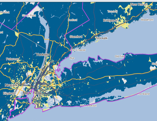
You got the call, people. Let’s rise to that challenge! I think the best way to deal with it is to bring prices down by building a diversity of relatively dense housing where there already is good transit, but many people will move to the suburbs, and some already have. WNYC made an incredibly useful map showing median income by census tract, based on the 2007-2012 American Community Survey. Here’s the New York area:


Interestingly, on this map the real concentrated poverty that we see in Fort Greene or West Farms – census tracts with median household incomes below fifteen thousand dollars – is only found in three places outside of New York city: Bridgeport, New Haven and the Seth Boyden and Otto Kretchmer projects in Newark (now closed). Instead, there are a lot of census tracts with median incomes between $15,000 and $25,000 a year. But outside of New York, Bridgeport and New Haven those are found in only a handful of other cities. In the rest of the metro area, median income is over $25,000.

The towns that have census tracts with median incomes between $15,000 and 25,000 are as follows: In New York State, Yonkers, Mount Vernon (one project), Spring Valley and Kiryas Joel. In New Jersey it’s Jersey City, North Bergen, Newark, Elizabeth, Asbury Park, Passaic and Paterson.

The primary challenge with the "suburbanization of poverty" is that the farther out people move, the harder it is for them to access good-paying jobs. Someone who is displaced from Fort Greene in Brooklyn to the West Ward of Newark trades a 45-minute subway ride for a trip on a bus to a commuter train to a subway that can take over an hour. Interestingly, it's not so much the cost of transportation that's the problem, as we can see by looking at the Center for Neighborhood Technology's Housing+Transportation index. In all these areas, housing and transportation costs combined were less than 45% of household income (indicated by yellow), which was often not the case for "wealthier" areas nearby (indicated by blue).


Here's the tricky part: these are based on the reports of people who had work, so they could by definition afford their commutes. It may be that the reason they can't access better-paying jobs is that they couldn't afford the commute, but we don't know that. Giving the H+T data the benefit of the doubt, we should focus on making the commute to better-paying jobs quicker, not just cheaper. That means increasing the capacity of the routes to job centers - primarily New Jersey Transit and Metro-North trains - and bringing rapid service to places, like Newark's West Ward and Yonkers's Schlobohm Houses, that are currently only accessible by relatively slow buses.

In future posts I'll talk about some potential investments that could improve job access from these areas.

Monday, October 14, 2013

The Eighth Borough


Some things that have been called the sixth borough of New York City:


Some things that have been called the seventh borough of New York City:

Some things that have been called the eighth borough of New York City:

Sunday, May 19, 2013

We can't depend on the Northeast Corridor

The big news this weekend is the major derailment and crash on the New Haven line between Fairfield and Bridgeport yesterday. The National Transportation Safety Board is shutting down that entire stretch of track for several days while they do a thorough investigation, and only after that can the repairs begin.
Metro-North and Amtrak trains are suspended indefinitely in both directions, and the lack of alternative service is just pathetic. "If all the trains use the same tracks, it doesn't really seem like there are many alternatives for getting into the city," New Haven resident Robert Li told the Stamford Advocate. "Especially if you don't have a car." There were bus bridges to get people home last night, but there are no buses, let alone trains, all weekend. This evening Eric Gershon of Yale News tweeted, "830 pm Peter Pan bus NYC to New Haven packed due to Fri MetroN #train #derailment. Long lines, short tempers at Port Authority."

Jim Cameron of the appointed Connecticut Parking Garage Rail Commuter Council has been tweeting up a storm. Unfortunately, he's been talking almost entirely about where you can drive to catch a train on Monday morning, I guess because he thinks people who don't drive - or don't want to be behind the wheel in a mess like that - aren't part of his constituency. Most of his tweets about buses are along the lines of, "No way you could handle that many people with buses," but he seems to think that the highway and parking infrastructure is more than up for the task. Yeah.

Anyway, there's a major rail outage, and that means it's time to play the "what if these people actually gave a shit about the riders?" game! Back in 2007, the bridge over the Thames River between Groton and New London was being replaced, and in 2009 it was the Niantic Bridge being replaced. In both cases Amtrak completely suspended service for an entire weekend, and in both cases I pointed out parallel train lines that could be used to bring people between New York and Boston, in particular the Inland Route (currently a slow, non-electrified line with low platforms) and the Air Line (currently railbanked as a trail).
Amtrak and the states of Massachusetts and Connecticut are now working to upgrade the Inland Route, in part due to a large influx of stimulus money, and Amtrak's Vision (PDF) for the Northeast Corridor includes a parallel route through the middle of Connecticut. Unfortunately, that part of the Vision is expected to cost $58 billion (with a "b") and not go live until 2040.


In the meantime we can work on the existing track. It would cost a lot less than $58 billion to rebuild the New Haven and Derby Railroad, abandoned in 1932, and to upgrade the track on the Berkshire Railroad and the New York and New England, electrify them and install high level platforms at stations. This would ensure that Northeast Corridor and Metro-North trains can go from New Haven to Stamford and get back on the main line, or to Brewster and get on the Harlem Line without having to pass through Bridgeport. (For that last you would also have to convert the Harlem Line to catenary power.)

For a lot less money, you could simply have diesel locomotives pull Amtrak cars through the Inland Route and along the unelectrified track from Meriden through Waterbury and Danbury to Stamford and maybe White Plains, with temporary platforms at a few stations. You could run extra shuttle service from Bridgeport and New Haven to meet the train in Meriden and Waterbury, and in Stamford and White Plains people could transfer to electric trains to Manhattan. It would be slower and less frequent than normal service, but it would be a lot better than nothing.

With the way that Amtrak and Metro-North are currently handling this, it looks like there are a lot of Connecticut commuters who will have a long, slow commute on Monday. I hope you'll all take the time to write to Governor Molloy and to Jim Cameron urging them to put an alternate route in place.

Sunday, November 18, 2012

The Cap'n's Bookshelf: Two Coots in a Canoe and Becoming Odyssa

One of my recreational pleasures is reading what I call self-propelled travel memoirs. I can't stand travelogues that are full of passages like "Our driver warned us..." and I have a hard time relating to windshield memoirs. I like Paul Theroux's books about train travel, and his books where he travels partly under his own steam, like Kingdom By the Sea where he walks a good deal of the way around the coast of England, and The Happy Isles of Oceania, where he kayaks around a number of Pacific islands (traveling between them by ship and plane). I've discovered a number of memoirs by other authors that involve long walks, bike rides or paddles.

Earlier this year I read Two Coots in a Canoe, by retired conservation advocate David Morine, describing how he and his friend Ramsay Peard canoed the length of the Connecticut River. Morine's conversational style made for easy reading, but some of the emotional content was honest and raw, with a surprising twist at the end.

One intriguing aspect of this memoir was that Morine and Peard, both around sixty years old at the time, agreed that they wouldn't camp out once during the trip. Instead they collaborated with other conservation advocates and used the connections they had built over their lifetimes to arrange for free room and board, usually with local activists involved in preserving or restoring a section of the river. In giving voice to these activists and describing their campaigns, Morine paints a picture of the current state of the river and the challenges in sustaining its flow and its wildlife.

After I finished that, I read Becoming Odyssa, an Appalachian Trail memoir by Jennifer Pharr Davis. Pharr Davis's style is a bit overwrought with metaphors, but she gives you a good feel for trail culture, and her honest discussions of her own emotional reactions to the trail are insightful and illuminating. As an atheist, I appreciated that she described her Christian religious beliefs and observances as matters of fact without any attempt to proselytize.


Sustainable transportation advocates will be most interested in the passage when Odyssa (as the author named herself, an Appalachian Trail tradition) comes upon the scene of a suicide. Realizing that the deed has been done, she numbly continues on the trail and dials 911 from her cell phone. On page 204 there is this exchange with the dispatcher:

"I need to know where your car is," she said.
"I don't have a car. I hiked here."
"Well, where did you park your car?"
"I didn't park anywhere. I'm an Appalachian Trail thru-hiker."
"What county are you in?"
"I don't know what county I'm in. I'm at Sunrise Mountain in New Jersey."
"So where do you live in New Jersey?"
"I don't live in New Jersey."
"Then where is your car?"

After ten or fifteen minutes of this, someone else in the 911 call center overhears their conversation and tells the woman "Patch her through to the police now."

Pharr Davis may not have had a car at the time, but in both books I was struck by how much time all three travelers and their companions spent being driven around by friends, relatives and hosts. The amount of driving involved in the average Appalachian Trail through-hike is pretty amazing.

Saturday, August 18, 2012

Why we can't have real crosswalks in New York City

As I wrote the other day, Queens is full of "unsignalized" intersections, where one street has a stop sign and the other has none. Practically speaking, pedestrians have no rights at all when crossing at these intersections, even though under the law we have the right of way.

Since around 2003, New York State law has said that cars must stop for pedestrians in crosswalks. Under the law, a crosswalk is "That part of a roadway at an intersection included within the connections of the lateral lines of the sidewalks on opposite sides of the highway between the curbs or, in the absence of curbs, between the edges of the traversable roadway." So you know that piece of pavement in between the sidewalks, with no markings on it? Yeah, that's a crosswalk.

Other towns post little signs at intersections to notify drivers of their obligations, like this one:


This one is in New Canaan, Connecticut, but I've seen them in other places, including towns in New York State.


So why can't the New York City DOT just put them out in every unsignalized intersection in Queens? A neighbor of mine asked them to put one on his corner, and they said that it was "not warranted." That's a technical term in traffic engineering meaning that the conditions aren't right for it, but what are the "warrants" for one of these?

My understanding is that traffic engineers are afraid of being blamed for a pedestrian getting hurt or even killed. They imagine that someone will see the sign, think that they're in Northampton, and try to cross the street. Crazy New York drivers will try to run them off the road, but the pedestrians will stand their ground, because, you know, the sign. And they'll get hurt and it'll be the engineer's fault.

Now I know what you're thinking. You're thinking, "these engineers care whether pedestrians get hurt? Really? Then why the FUCK don't they care about deathtraps like Brighton Beach Avenue and West Street? Why do they keep widening roads and taking away parking lanes?"

The answer is that they don't actually care about the pedestrians, they care about their reputations. If a pedestrian gets killed trusting one of these signs, that hurts the engineer's reputation. If a pedestrian gets killed because of the parking restriction on Northern Boulevard, the engineer's reputation is protected through the magic of LOS.

LOS stands for "level of service," and it refers to how smoothly traffic is flowing. Most of the shitty, dangerous road designs you've had the displeasure of experiencing are justified by maintaining a good LOS. The LOS is designed for highways, so it says nothing about pedestrian throughput, safety or comfort. And that means that if pedestrians get killed on Northern Boulevard, everyone up to Janette Sadik-Khan says, "well, it's a shame she had to die, but at least she gave her life for the LOS." No matter how many pedestrians die, the LOS will protect the engineer's reputation. And that's why we can't have real crosswalks in New York City.

Thursday, March 24, 2011

A missed opportunity for rail-oriented development

Another of the many things that make the overnight casino bus crash so frustrating is that even if there was no possibility of changing the law to allow gambling closer to the city, the location they used would still have been ideal for rail.


As Arcady pointed out in the comments to my first post on this topic, the casino that the bus was returning from, Mohegan Sun, is located right next to the New London and Northern, an active freight line that is currently part of the New England Central Railway. It would have been a tiny part of the resort's construction budget to build a station there.

Mohegan Sun is one of the largest casinos in the country. Curiously, its biggest competitor, Foxwoods, is just a few miles away across the Thames River. Foxwoods is located at 350 Trolley Line Boulevard, so named because a branch of the Shore Line Electric Railway ran down it. I don't have any maps or pictures of the old line, so I don't know how easy it would be to rebuild it or to link it to the nearby Providence and Worcester line, but the location was once served by rail.

The Foxwoods website says that it's served by over a hundred buses a day. According to the Mohegan Sun website, over twenty buses a day arrive there, but I think the real number is higher. There is definitely the ridership to justify reactivating passenger service on that line. Arcady writes, "they'd need a new station and permission to run more trains across that drawbridge east of Old Saybrook."

It's true that there are only five Shore Line East trains a day that cross the bridge. It's also true that most of the Amtrak trains that go through New London are pretty full. But the Shore Line East trains could be extended to Mohegan Sun and beyond, to Norwich, Willimantic and even Mansfield Depot, just a few miles from the University of Connecticut. If the line is electrified, trains could run directly from Penn Station or possibly Grand Central.

The Niantic River Bridge is being replaced, and the new bridge will allow for more trains, and the upgrades to the Hartford-Springfield line could relieve some of the congestion on the Shore Line, but it's still a drawbridge that has to be raised for boats to go under, and the number of trains will be limited.

Some of the trains could be operated as shuttles from New London, or perhaps even Providence with an awkward change in direction. Would gamblers from, say, Chinatown, put up with a three seat ride (subway, mainline train, shuttle) instead of a one-seat bus? Probably not during rush hours, but during off-hours they could get a two-seat ride, and it might just boost ridership enough to make regular local service on these lines viable.

If you're thinking it's too expensive, just take a look at satellite photos of the area, and marvel at the amount of money that was spent on bringing cars to these resorts. New stations at Mohegan Sun and Norwich would cost a fraction of one of those parking lots, and rehabbing the rail line would be within the same range. The main point is that these casinos could have been major drivers of rail expansion in the area, but instead they were boosters of the road infrastructure.

Friday, November 20, 2009

Transport Azumah begins service to unconventional city pairs

Today was the first day for Transport Azumah's new service between New Haven and Boston. Next week, Azumah will begin running buses on several underserved routes between cities in the Northeast: New York and Cambridge, and New Haven and Philadelphia/Wilmington/Baltimore/DC.

The Harvard Crimson quotes Joel Azumah as saying that there will not be wifi or power outlets until the spring, but we've got it straight from the horse's mouth that unboxed bikes will be allowed "as long as they are tagged with the owner's name and contact phone."

Azumah didn't take me up on my suggestion to stop in White Plains and connect with trains to Manhattan and the Trailways and Shortline buses to Long Island and the Hudson Valley, but hey, he's the one with the hands-on experience, and it's his money on the line. Let's all wish him success in adding to the travel options in the Northeast - especially for cyclists!

Thursday, October 1, 2009

Transit versus highways in Connecticut

Last week I argued that a two-way dedicated busway on the Long Island Expressway would help make bus service between New York and points north and east faster and more reliable. That would boost ridership on these services, making the for-profit companies more reliable and the government agencies less dependent on subsidies.

Joel Azumah has been weighing the potential profits to be gained from running buses to New Haven, so I asked him what he thought. He observed, "I think CT's bus issues stem more from I-95 being erratic when it comes to congestion."

I've been thinking a bit about this corridor lately, since both Metro-North and Connecticut Transit are facing budget cuts. It got me wondering what the government might be doing to subsidize driving there. It turns out to be quite a lot.

1937: Hutchinson River Parkway
1938: Merritt Parkway
1949: Wilbur Cross Parkway
1958: New England Thruway and Connecticut Turnpike
1967: I-84
1974: I-684
1988: I-691
2001: Widen Turnpike in Stamford
2004: Widen Turnpike in Bridgeport

You could argue that the tolls on the Turnpike were "user fees," so that all the highways built or maintained with this money were not directly subsidized. That argument went out the window when the state removed the toll booths on the Turnpike in 1985. At the time politicians tried to claim that it would be paid with an increase in the gas tax. Regardless, it's clear that the State of Connecticut has been spending billions to help people drive quickly in the corridors that parallel the New Haven line.

This affects the amount of subsidy required for Metro-North and Amtrak, and thus the number of trains that can be run and the fares charged. As Azumah observed, it also affects the profitability of Greyhound, Peter Pan and any other bus lines that might want to operate in that area. It even affects the service and fares on the buses paid by CT Transit, because many people use these highways for local trips, reducing bus ridership and starving them of revenues.

What could transit advocates do to restore competitiveness to transportation in this area? First of all, oppose any new widening projects. There are currently none that I know of on the horizon, but there are lots for the Turnpike east of New Haven. Second, press for tolls to be reintroduced, not just on the Turnpike but on the Merritt and Wilbur Cross, and on I-84, I-684 and I-691. Tolls on the Turnpike should be set at rates that would return traffic to levels where it will not interfere with intercity bus operations. Other options would be to use some of the lanes added in Stamford and Bridgeport as dedicated bus lanes.

Wednesday, September 30, 2009

Transport Azumah to inaugurate New Haven-Boston service with unboxed bikes

Last month I discussed strategic problems with New Haven transit advocates' campaign to convince Greyhound to run BoltBus service to New York, and the possibility that Transport Azumah might enter the market. I also described how the infrastructure built by the New York City and State governments favors private driving over bus service.

In the comments for the SeeClickFix issue regarding BoltBus service between New York and New Haven, some argued that service to Boston was a higher priority, since there is no Metro-North service and the Greyhound/Peter Pan consortium has a monopoly on bus service. Transport Azumah apparently concurs: Joel Azumah writes that he will be starting weekend service between Boston and New Haven beginning on Thanksgiving. A tentative schedule is posted on his website.

Many New Haven residents said that they wanted BoltBus because of specific features that they couldn't get on Greyhound, like dynamic online ticket pricing, leather seats, and onboard wifi and power outlets. The dynamic ticket pricing is in place. Azumah tells me that wifi and outlets won't be available right away, but he hopes to be able to offer them soon. No word on leather seats.

The other key feature that many potential riders wanted is a convenient bicycle policy. This is a big deal because it allows true multimodal travel. Amtrak requires all bicycles on Northeast Corridor trains to be partially disassembled, boxed and checked as baggage; Greyhound has a similar policy. Peter Pan allows bicycles "in an empty cargo bin," but if all the bins have at least one bag in them, the cyclist is SOL. In contrast, BoltBus says, "We do allow them and consider them to be oversize items as long as space is available in the baggage area."

TransportAzumah's policy will be similar to Bolt's. Azumah writes, "We will be able to take unboxed bicycles as long as they are tagged with the owner's name and contact phone." That is a huge improvement over the current options for travel in this area.

Here's wishing Azumah success in this venture. He's listened to what people want, and is trying to provide it at an affordable price. Let's hope that by this time next year he's able to provide daily service between these two cities.

Does anyone know of competing road projects along these possible routes that could draw riders away and sabotage Azumah's chances of success?

Monday, September 21, 2009

Faster, more reliable buses to Connecticut and beyond

In the comments to the original Design New Haven post about wanting better bus service, some folks mentioned that the New York-Hartford Megabus run was unreliable and took a long time. This was also mentioned by several commenters on the corresponding SeeClickFix issue, and there seems to be a consensus that buses from New York to Connecticut and points beyond (a) take longer than they should and (b) can sometimes take a lot longer. Everyone knows why: they get stuck in traffic on New York City streets.

As I've written before, the enduring profitability of the west-of-Hudson routes is due in large part to the Lincoln Tunnel Exclusive Bus Lane, which has been making bus commuting competitive with cars since 1970. Although the Port Authority has dragged their heels on the long-overdue expansion of the XBL, which has been at capacity since the late 1980s, they have continued to operate the lane.

Another factor is the huge number of general-purpose lanes feeding into the tunnel approach, which allow the buses to move relatively smoothly even where they don't have a dedicated facility.

If you go to the Port Authority and get on a bus to Montclair or Newburgh, your bus will go right out of the terminal and into the tunnel, with at most two blocks of street shared with private cars. By the time you're on the Turnpike or Route 3, traffic is usually flowing pretty smoothly for everyone. Relatively little of the route is on the general-purpose streets with frequent bus stops that put buses at such a disadvantage.

Now if you get on a bus to Hartford or Providence, your bus might go right out of the terminal and onto Tenth Avenue. There's no bus lane on Tenth Avenue, so you're mixed right in with the cars and trucks, and if traffic is bad, you're stuck in it too. If a light turns red, you sit there, and if someone blocks the box, you could be sitting there for a long time. So it goes up Tenth Avenue and Amsterdam Avenue. At some point the bus crosses to the East Side and gets on the Bruckner Expressway. There are no traffic lights on the Bruckner or the New England Thruway, but sometimes car traffic can get congested. The Bruckner has no bus lane, not even an HOV lane, which means that any bus is going to be slower than a corresponding car trip. Getting back is similar, except you're going down Ninth instead of up Tenth.

Because of this, some bus operators will actually use the XBL even for trips to Connecticut. That's right, they will go west, through New Jersey, up the New Jersey Turnpike and across the George Washington Bridge to the Major Deegan Expressway, and from there to the relatively less-congested Interstate 287 to 684 to 84. According to Google Maps, that adds about fifteen miles to the trip, but you know they've figured out that it's a more reliable - and often faster - route.

So why do we care if the buses are slow and unreliable? There's train service; shouldn't we put our government dollars into making that better? Well, maybe not; the old New Haven mainline is pretty much at capacity right now, and it's clearly not serving all the people who currently drive on these highways. Many people want a one-seat ride to a place that's not on the train, like Stockbridge or Northampton. Others want a level of comfort that they can't get on Metro-North, but maybe aren't willing to pay Acela rates. Some, as has been said before, want wifi, power outlets and a place to stow their bicycles.

We want to decrease the demand for building and rebuilding the highways of New England. We want to decrease the pollution and carnage along I-95 and US 1. We want these drivers to shift to the bus, and to do that the bus has to be at least as fast and reliable as the car.

That's why buses heading to the north and east need their own XBL, where they can be free from intersections and car traffic until they get to less congested highways. Ideally, this would be highway all the way. Why don't these buses take the LIE to the Whitestone Bridge? Well, thinking back to the few times I've attempted to drive the LIE at any time near rush hour, it was a lot slower than the Turnpike. The short morning rush HOV lane doesn't seem to be enough. If we had a bi-directional, 24/7 dedicated busway from the Midtown Tunnel to the Van Wyck Expressway, you know those buses would be flying out to Connecticut.

The LIE is a touchy subject with some people, so it wouldn't surprise me if it were difficult to get that bus lane approved. A less ambitious plan would put bus lanes on Ninth and Tenth Avenues (and Amsterdam and Columbus), similar to the ones on Fifth and Madison for the East Side. Don't West Siders - and Riverdale residents - deserve as much?

Sunday, September 20, 2009

New Haven bike-n-wifi bus update

Following the comments on SeeClickFix is a little difficult because of all the repetitive "Another person wants this fixed!" auto-comments. But in among those on the New Haven BoltBus issue (discussed here previously) are a few interesting news items. User Mark points to a Yale Daily News squib that reports that TransportAzumah CEO Joel Azumah has taken interest in the market. "Azumah said he is currently drafting a tentative schedule for the service to show the New Haven community, adding that if feedback is good, the line should run in time for Thanksgiving break."

Some readers will remember TransportAzumah as one of the more entrepreneurial bus operators in the New York area. It was Azumah who stepped in when Coachusa dropped the 144 route from Staten Island to Jersey City in 2007. He was rewarded for this by seeing the MTA run competing service; watch this video for Azumah's take on the events, plus a jaw-dropping quote from now-Congressman McMahon.

If the New Haven riders are looking for Boltbus comforts on the cheap, they probably won't get leather seats from Azumah. On the Staten Island run, customers complained that the buses were old and not very well-maintained - particularly regarding the bathroom plumbing. Azumah also has a relatively small fleet and contracts out with other operators for any additional buses he needs; consequently he has less control over the amenities on the ride. But it's clear that if he had had more than six months before he had to compete against subsidized service, he would probably have been able to take care of some of those issues.

Azumah is young, techno-savvy, and a regular contributor to various online transit forums around the New York area (like BusChat). I'm sure he understands the value - and potential draw - of onboard wifi. I'm guessing by his name that he has probably also been to Ghana and seen how for-profit transit operators act in a true free market. He has released a detailed proposal for express bus service from Long Island, and I think he may also be the author of this one for restoring competition to NYC buses. He might be able to set up the Boltbus-style dynamic ticketing scheme that the New Haven residents like so much. His entry into the New Haven discussion - and his potential entry into the market - could really bring a lot.

Wednesday, September 9, 2009

Greyhound is not a government agency

New Haven residents, apparently, have spent so much time with government-run transit agencies that they've forgotten how to deal with a for-profit company. That's the message I'm getting from this Design New Haven post featured on Streetsblog.net this morning. The SeeClickFix website (founded in New Haven) is a forum for people to post local non-emergency issues that they would like their government to act on. "About 1 month ago," SeeClickFix co-founder Ben Berkowitz posted an issue, "Bolt Bus Should Run From New Haven to New York," which has become one of the most popular "fixes." It has attracted the attention of Alderman Greg Morehead, who sponsored a resolution that was passed unanimously by the Board of Aldermen on Tuesday, and has used the issue in his re-election campaign.

In theory, this is nice to see: people want transit! But note that the New Haven-New York route is not exactly transit-starved. Metro-North runs hourly commuter rail service ($14), supplemented by more frequent trains during peak times. Amtrak runs almost-hourly Regional service ($26) and an additional almost-hourly Acela Express service ($61). Peter Pan and Greyhound also run a total of ten daily buses between the two cities ($25). If you're in Union Station (the initial suggestion for this desired Bolt Bus service) you've got four options at three different price points.

So why do so many people want BoltBus? It can't be for the company: BoltBus is just a special premium service offered by Greyhound (which in turn is owned by the Scottish company FirstGroup). It could be the price: Bolt uses computerized airline-style variable pricing, with at least one seat on every bus selling for a few dollars. But the Yale Daily News writes, "Greyhound Lines spokesman Timothy Stokes said the company has no plans to expand the BoltBus to New Haven, or any other city." They've clearly decided that at this point they're not going to make money by running the Bolt service to New Haven, so the New Haven residents couldn't be pressuring them to run it at a loss, could they?

But it could be the service: Bolt has free wifi and electrical outlets, more legroom and leather seats. They also have a friendlier policy towards bicycles, allowing them to be stowed in the luggage compartments without being boxed up. The other services can't match all these features: Amtrak has the legroom and electrical outlets, but they don't allow unboxed bikes on the Northeast Corridor or offer wifi. Metro-North allows bikes on off-peak trains, but doesn't have any of the other amenities.

So let's assume that it's the service. Why does it have to be Bolt? On the New York to Boston run there are at least two competitors. Megabus (owned by another Scottish company, Stagecoach) also offers wifi and electrical outlets, with a similar pricing scheme. Limoliner offers wifi and outlets, plus wider seats, more legroom and an attendant, and just started running to Hartford for a flat price of $49 (which is probably beyond the budgets of most students, even Yalies). No word on the bicycle policy. Did anyone from New Haven approach Megabus or Limoliner?

Since Stagecoach recently sold most of their New England bus operations to Peter Pan, and Peter Pan operates under an agreement with Greyhound, Megabus may be unwilling to enter the New Haven to New York market. But there are a number of other bus operators in the region, many of which serve the nearby Foxwoods and Mohegan Sun casinos. If there are profits to be made, one of them could probably be convinced to outfit their buses with the necessary amenities and make the run. Or even a brand new start-up.

If there are profits to be made. That's the big question, isn't it? Apparently Greyhound doesn't think so - or at least, not enough to justify putting resources into right now. On the other hand, they are currently rolling out wifi, outlets and legroom under their own brand on their most popular routes, and maybe New Haven will come soon. But if the New Haven residents really think Greyhound is wrong, why not prove it? Yale has an economics department, and a world-renowned MBA program. Surely they could find a grad student willing to spend a day crunching the numbers. If they're good enough, it would convince any bus operator.

And if there aren't profits to be made? I don't think any amount of aldermanic resolutions are going to convince a private company to subsidize intercity bus travel. There's not even any point in asking the government to subsidize the service, since there's already subsidized transit between the two cities. It doesn't have wifi, but beggars can't be choosers. If it's wifi you want, then you'd have better luck petitioning Metro-North to install wifi.

The bottom line is that this isn't really an issue for government. But I would like to see better bus service, so I hope that the people of New Haven can get the numbers crunched and find out that it really could be profitable for someone.

Wednesday, August 12, 2009

Planning the next New York transportation network


As I wrote in earlier posts, Paris's Regional Express Network (RER) of commuter/rapid trains was not simply designed to make connections, but to accomplish specific development goals. The same 1965 SDAURP (Master Plan for the Urban Development of the Paris Region) that laid out the RER also planned the development of the five "new towns" around the region and the suburban campuses of the University of Paris. Anticipating a new wave of residents who would study and work in the area, regional planners under the direction of Paul Delouvrier, the General Delegate to the District of the Paris Region, designed these train lines to connect residential developments with universities and job centers. They also aimed to relieve congestion on certain metro lines that were overloaded, particularly the 1 and 4 lines, the main east-west and north-south lines in the system.

Any similar system in New York should take into account similar planning goals. One of the reasons that the New York area is so fragmented is that we don't have a single Delegate, or a single regional planning agency. Instead we have three Metropolitan Planning Organizations (MPOs): the New York Metropolitan Transportation Council Council (NYMTC), the North Jersey Transportation Planning Association (NJTPA), and the Southwestern (Connecticut) Regional Planning Authority (SWRPA). Each of the three have come up with plans similar to the SDAURP, some better than others. We can piece them together to get an idea of the priorities that our planners have.

Of course, these plans should be viewed with some skepticism. Although the planners are supposed to act in the best interests of everyone in the region, they have been known to occasionally fail in that task. Also, different people have different priorities, and you will probably not have the same priorities as these planners. With that in mind, I will probably revisit these plans and question them - and I encourage you to do the same on your own blogs or in the comments. In the meantime, though, let's operate on the assumption that the planners share our priorities, are working in the best interests of everyone in the region, and are knowledgeable and competent.

The NYMTC has actually just released their draft plan for 2010-2035. The NJTPA has their draft Long Range Plan for 2035 available, but in some ways the New Jersey State Plan is more valuable. The SWRPA released their plan in 2006, and it can be downloaded as a PDF from the Town of Weston's website.

I'll talk more about these plans in future posts, and their implications for future transit improvements, but feel free to have at them in the comments.

Thursday, July 23, 2009

Niantic Bridge gets stuck...

The Day has the story. Fortunately, it was in the position where it disrupted boat traffic (mostly recreational) not train traffic. Anyone up for a little proactive redundancy, in case it gets stuck in the wrong position before they can replace it?

Friday, July 3, 2009

NYC-area bus networks - east vs. west

The greater New York area has one of the best train networks in the country. However, there are some major gaps in this network. West of the Hudson, these gaps are filled by an extensive bus network. It's not as convenient as the train, but most towns from Point Pleasant Beach to Albany have daily bus service, with routes stretching deep into the Poconos and Catskills. These are relatively new, clean, comfortable buses, and most of northern New Jersey has hourly service or better. Much of it is provided by private operators at a profit.

Now let's look east of the Hudson. There are three major private companies, which stick to established routes: Bonanza up the Hudson and Housatonic valleys; Bonanza, Peter Pan and Greyhound along the shore and up the Connecticut River valley.

The State of Connecticut and the New York counties of Westchester, Putnam and Dutchess run subsidized bus systems, much of which is the infrequent, indirect "charity bus" service familiar to transit advocates from other parts of the country. Of these public systems, only one, the Westchester Bee-Line, brings passengers to the city, and only one Bee-Line route, the BxM4C, goes to Manhattan. (Judging by the name, I'm guessing that this route is a relic of the express bus routes formerly operated by Liberty Lines, which runs the Bee-Line system under contract to the county. The BxM4A and B, which did not go into Westchester, are now operated by the MTA Bus Company.)

On Long Island, there's one major private bus company, Hampton Jitney, which offers near-hourly service from Manhattan to and from the South Fork, and less-frequent service to the North Fork and Westhampton. Intercity carriers New York Trailways and Coachusa each offer three runs a day from their core areas in the Catskills and Adirondacks through Nanuet, White Plains and Queens Village to Hempstead and other major towns on Long Island. I'm pretty sure that Greyhound offers at least one run a day, but I don't have more details.

Local bus service in Nassau County is provided by Long Island Bus, which is under the MTA umbrella. There is very frequent service on some lines (for example, Hempstead Turnpike sees buses every few minutes at some times), and others not so much. The Town of Huntington is served by Huntington Area Rapid Transit, and the rest of Suffolk County by Suffolk Transit, and both of those are charity bus services.

Coming up, I'll talk about how this dichotomy affects commuting patterns, and what it means for future transit development.

Saturday, June 13, 2009

Being proactive about the Niantic River Bridge

Following up on last year's replacement of the Thames River Bridge in Connecticut, Amtrak has received $105 million in stimulus funds to replace the Niantic River Bridge a few miles to the west. This is good, and will not only allow Acela trains to go faster, but will avoid slow orders that would be required if the bridge deteriorates further. The new drawbridge will also be taller and longer than the current one, meaning that it will not have to open for boats as often, allowing Amtrak to run more trains.

Unfortunately, as with the Thames bridge, this replacement will probably require Amtrak to shut down the Shore Line again. Last time, after objections from passengers, Amtrak agreed to run an alternate train along the Inland Route - but only one.

Let's see if we can do better this time. Stimulus money is already being used to fix broken cars, so Amtrak will hopefully have more equipment available. It would be nice if some of the money could also be used to upgrade the Inland Route. That would allow them to run more trains, not just for this outage but over the long term, serving more communities and providing needed redundancy.

As I've written before, to bring the Inland Route up to the standards of the Shore Line we need more tracks, electrification and high-level station platforms. As far as I know, the old Hartford line and Boston and Albany line never had electrification or high-level platforms, but they did have two tracks for almost this entire route. As I understand it, the second track on the Hartford line was scrapped some time during the 1980s. Some awesome guy has posted track maps for the B & A showing it as two tracks from Rensselaer all the way to Framingham, and four tracks from there to Boston.

How much would it cost to restore the second track? Fortunately, the Connecticut Department of Transportation has done a study of just that, for the always-just-around-the-corner New Haven to Springfield "commuter train." Bizarrely, although the study documents were online just a couple weeks ago, they now seem to have disappeared. Let's see how much of it I can recall from memory.

Basically, they say that you would get enough of a performance boost from double-tracking part of the line, and they recommended not double-tracking the entire line all the way to Springfield right off the bat. On average, it could be done for about $800,000 per mile. I don't think that includes the switches and signals necessary to make full use of the double tracks, and I'll be damned if I can remember what the total was for that whole section of the line. The shortest single-track section east of Springfield is the one between Springfield and Palmer, only about eight miles. It could be completely upgraded for a lot less than ten million dollars.

For a few million, we could get one additional double-tracked section, which would probably be enough to run two trains a day during the outage and any subsequent outages, and permanently increase capacity on the line. Amtrak is planning to spend $100 million of the stimulus funds on replacing the bridge. They should try and get a few more million for double-tracking the Inland Route. They could either upgrade the Hartford line and save Connecticut a few bucks whenever they get around to upgrading service, or they could upgrade the ex-B & A line between Springfield and Worcester, and although those tracks are owned by CSX as part of their Boston Subdivision, an upgrade would improve the running of Amtrak's Vermonter and the Lake Shore Limited trains.

Either way, we should be spending more to mitigate the impact of this outage, and these would be permanent improvements that would benefit the system in the long run.

Saturday, May 23, 2009

Redundancy and the Northeast Corridor

In my last post, I talked about the value of redundancy in transit networks. Connecting this back to our goals, I think this speaks more to the relative value of transit over cars. If you've got a robust transit network (thanks to commenter Most but not all on the last post for that term), you can compete with car networks that strand people if they lose access to their cars. If you have a sickly transit network, like the commuter rail lines that only run during rush hours, you'll lose people to cars whenever it's practical to drive.

One network in need of robustness is the Northeast Corridor train line from Washington, D.C. to Boston. If you want to go from Boston to Washington by train, you have to go through New Haven, New York, Newark, Philadelphia, Wilmington and Baltimore. As we saw with last year's Thames River bridge outage, there is a little bit of redundancy between New Haven and Boston provided by the "Inland Route" through Springfield, but even that is not electrified between Springfield and Framingham (I think), and is single-track for most of that stretch with heavy competition from freight.

I'm less familiar with the Delaware/Maryland area, although Wikipedia says there are three routes from Washington to Baltimore, all in good condition and currently used for passenger rail: the former Pennsylvania mainline currently used by the Northeast Corridor, the CSX Capitol subdivision used by MARC commuter trains, and the CSX Old Main and Metropolitan subdivisions, partly used by MARC. But if anyone has other ideas about pinch points there (and information about the electrification status of any of these lines), feel free to leave them in the comments.

Between Baltimore and New Haven there is simply no alternative to the mainline. Compare this to the Peter Pan buses, which routinely switch between Interstate 95/91 and Interstate 684/84 to get from New York to Hartford, depending on where the traffic flows better. This is not an argument for buses or cars, it's an argument against sickly, non-redundant rail infrastructure. There are tons of pinch points along the Corridor that would completely disable large sections of it. We've seen the Thames River, and I'll mention a few others and how we could get around them.

The first pinch point I want to mention is the Morrisville-Trenton Railroad Bridge over the Delaware River. However, there is a bridge just four miles upstream that is used for electrified SEPTA commuter rail from West Trenton to Philadelphia. The currently-unfunded project to reactivate passenger service from West Trenton to Newark would provide an alternative route for less than $200 million (plus electrification).

The next pinch points are the bridge over the Passaic River in Newark and the Portal Bridge over the Hackensack River in Secaucus. The century-old Portal Bridge is a known weakness and is due to be replaced in the next five years - but because it's so essential, the replacement project will be huge and complicated. There's also the Hell Gate Bridge over the East River.

But let's skip those for the moment and consider the weakest point in the whole corridor: the Hudson River crossing into Penn Station. Even if the ARC tunnel eventually connects to Penn Station (or even Grand Central), you've still got a huge amount of train traffic being routed through Midtown Manhattan. We could even consider the whole stretch from Newark to New Haven as a single, ninety-mile-long weak point. Currently, the nearest place where FRA-compliant trains cross the Hudson (other than the float bridge for freight trains) is Selkirk, NY, a little south of Albany. Passenger trains cross a few miles further up between Rensselaer and Albany.

As I've covered before, there are tentative plans to run commuter rail over the replacement for the Tappan Zee Bridge, but the focus is entirely myopically centered on "commuter rail" connecting the former Erie mainline at Suffern with the Hudson Line at Tarrytown. The (flawed) Tappan Zee process did consider running the line east to connect with the New Haven line in Port Chester, but rejected it because of low commuter ridership projections. The prospect of a more robust Northeast Corridor would bolster the argument for this new line.

I'll end it here for now. There's another idea I'll get to in a later post.

Sunday, January 18, 2009

My head exploded

Jim Cameron of the Connecticut Rail Commuter Council tells Newsday, "I don't know why we're talking about encouraging people to use mass transit when the DOT isn't doing anything to increase parking at the stations."

Sunday, January 4, 2009

Don't Give Rail Infrastructure to Buses

Whatever you may think about Bus Rapid Transit (and I'm not the biggest fan), I would hope we can get transit supporters to agree on this: it should not take infrastructure from trains.

I've established in previous posts that buses running in mixed traffic do not qualify as "rapid," and that it makes a lot more sense to talk about BRT corridors than BRT lines, so only physically separated corridors really count as BRT. If you want to build true BRT, the next question is where do you get the corridors?

You could build brand-new corridors, and some plans do call for that, such as the Rockland-Westchester corridor Option 3B where the DOT would build a viaduct above or a tunnel below Interstate 287 for the entire corridor from Tarrytown to Port Chester. But corridor acquisition is one of the major costs of transit construction, bus or rail, and the current estimate (PDF, page 3) is that BRT with a brand new viaduct in Westchester would cost $2.55 billion versus $897 million without. Light rail would only be $1.6 billion more, and most of that is probably for two proposed tunnels that are not strictly necessary.

You could acquire your corridor by converting lanes currently dedicated for mixed traffic travel or parking, and that's probably the best option for someone who really cares about effective rapid transit. That's what was done for the famous BRT prototypes in Curitiba and Bogota. More locally, the Fordham Road Select Bus Service (PDF) simply converted travel lanes on Pelham Parkway and parking lanes on Fordham Road to bus lanes. Yes, they're not physically separated, and they're not 24 hours, but they're still widely acknowledged to speed travel time.

You could also take over an existing or abandoned rail corridor, as the State DOT is proposing to do with the Piermont Line between Suffern and Airmont (PDF). It's been done in numerous cases around the US, including Pittsburgh, Los Angeles and Boston, and it's proposed for New Britain, Connecticut. This might possibly be a good idea for a very short segment - say a block or two - but otherwise it's a really bad idea.

Why is it such a bad idea? Because even in dedicated rights-of-way, buses tend not to attract the same numbers as trains: the Pittsburgh busways have never attained anywhere near the ridership of the rail lines that were maintained. If busways do manage to attract ridership, they often don't have the capacity to handle it. In Curitiba, the current busways are maxed out at 18,000 passengers per hour per direction, and in 2007 the government approved construction of an elevated rail system.

If you convert a rail ROW to a busway, attract a lot of riders, and then want to upgrade the ROW to rail again to handle the ridership, you have to shut down the ROW for long enough to lay down all the rail, rebuild the stations and whatever else might be necessary. Congratulations, you've inconvenienced thousands!

I don't care how old and stale the rail right-of-way is, if it's good enough for buses it's good enough for trains. If it's more than two blocks long, don't waste time and money with busways. Just find a way to make the trains work. That was true in Pittsburgh, and it's true in New Britain and Suffern.