Last week I singled out Richard Layman for repeating the chestnut "Spain doesn't have the population density to support economically many of the lines, based on ridership." Again, let me make clear that Richard is far from alone in assuming that density is required to support transit, and that his blog is informative, insightful and well worth reading for urban issues. He was also a good sport in leaving a comment on my post; unfortunately all the comments made it clear to me how deep the idea is ingrained in our understandings of transit.
A number of people have addressed this issue before. Richard mentions Steve Belmont and linked us to a scan from his book (see also David Alpert's take). Alon mentions Gary Barnes and his concept of "perceived density" (PDF); the Austin Contrarian has his own idea of perceived density.
I had a great idea for a phrase, "density is not destiny," but like most ideas it turns out that someone's thought of it before you; in this case it was Paul Mees, and Jarrett has an interesting discussion. But all these discussions are frustratingly myopic, assuming that the competing road network is a constant force of nature beyond political influence.
Instead of looking at the concept of "density," let's look at "support." What does it mean to support a transit line? Is it complete financial self-sufficiency, as Germà Bel demands for the Spanish high-speed network? If that's the case, then very few transportation projects anywhere would qualify. Is it the simple existence of the transit line? Then Newburgh's three-line transit system would qualify, since it exists, but that's not a very enlightening criterion. Is it a certain threshold of mode share, as the discussion at Greater Greater Washington would suggest? That's more promising, but it's not all.
Let's bring in some Strong Towns thinking. Chuck Marohn looks at any transportation project and asks, what is the return on investment? And it turns out the answer is connected to density. The ROI for a street, bus line, train line or ferry dock, it turns out, is dependent on the benefits derived from that investment. If it's a government investment, it has a "public ROI" indicating the benefits accrued to the public, whether in the form of tax revenue or any other goal.
ROI is the benefits divided by the costs. In transportation, sewers, utilities and other public projects, the costs are spread out geographically, so the ROI depends on the density of the benefits. That is where density comes in.
Sunday, January 22, 2012


Saturday, January 21, 2012
Navy Road and the projects
Ben Fried at Streetsblog said it all in just fifteen words:
I'm going to blather on about this for much longer than Ben just so that you might get the idea that there's something here, and pay attention to it, and maybe tweet a link to this post. But really, Ben said just about everything that needed to be said. If you like, you can stop reading and make your views known to the DOT and NYCHA and Councilmember James.
One of the reasons I write this blog is because there are things that get under my skin, and I just need to answer them and get it out there. One of them is people who think they've got a wonderful pro-pedestrian solution that nobody's thought of: pedestrian overpasses.
Sometimes pedestrian overpasses are the best solution. For example, when every other crossing of the Long Island Expressway involves fighting with half a dozen turning cars driven by entitled jerks, it's really nice to have your own little ramp with no cars around. In Strong Towns terms, pedestrian overpasses are good for crossing roads, which are in turn built to get cars from one place to another as fast as possible.
Most of the time, though, pedestrian overpasses suck. They're at their worst when they cross streets that have wide sidewalks and retail, like I've seen in Santo Domingo. In these cases, a driver who wants to cross the street has a huge advantage over the pedestrians who have to climb up, over and down. Underpasses, as used on Queens Boulevard and in Paris and London, are just as bad. In Strong Towns terms, pedestrian overpasses are bad for crossing streets. In fact, they're one of the ways that streets get turned into stroads.
So now let's turn to the topic of Ben's tagline: Navy "Street." The Brooklyn Paper story he linked to gave the basics: Navy Street is a popular route between Fort Greene and Park Slope to the south and the Manhattan Bridge and the Brooklyn-Queens Expressway to the north, and for two blocks in between (joined together into one superblock) it passes between two subsidized public housing projects, the Farragut Houses (population 3,440) and the Walt Whitman Houses (population 4,276). There are buffered bike paths on either side of the street, and fences blocking pedestrians from accessing or crossing the street from the projects. In the middle of the superblock there is a pedestrian bridge across the street from one project to another.
Every once in a while, some young sociopaths get the idea that it would be fun to go up on the bridge and throw things at the cyclists passing below. Last August, they hit computer programmer Stephen Arthur in the face with a brick, seriously injuring him. The city responded with typical bureaucratic non-solutions: they first stepped up police patrols of the area, and now they're going to cover the overpass with a mesh fence.
Ben's one-liner gets to the heart of the problem: why is Navy Street like this in the first place?
In Strong Towns terms, this section of Navy Street is not a street, or even a stroad. This is a road. It has fencing on both sides for the entire length. It's been about twelve years since I spent much time in that area, but I seem to remember that there was no bike path, just four lanes of car traffic. This road was designed to speed cars through the projects to the Manhattan Bridge and the BQE, without stopping or interacting.
If I lived in those projects, I would probably detest Navy Street for cutting my home off from other parts of the city and bringing noise to my building, just so that outsiders could get through the area faster. If I were an alienated teenager who'd spent his whole life as the target of abuse and discrimination from white people who were mostly well protected behind glass and steel, I'd want to throw something at those cars. And if I saw a less-protected, slower-moving, well-fed-looking white guy going by, I might just throw something at him. It's not right, but I understand where the impulse comes from. In some sense, you could say, they're angry at Bob Moses for designing the projects and the road this way, and at all the people who supported him, and at all the people who maintain this degrading Corbusian environment. They can't throw bricks at them, so they throw them at Stephen Arthur.
By putting in the bike lane, the DOT acknowledged that drivers going to the BQE are just not important enough to justify four lanes of traffic. The bike lane was a good start, but as Ben says, they need to finish the job. Arthur already asked the city to take out the fences, so that if the kids throw things at him again, he can at least try to chase them, but that would be counterproductive. The DOT needs to take down the road and put in a street that serves the project residents and not just the people passing through. As you can see from the pictures, there's room to put sidewalks all along the street. In the unused "open space" NYCHA can put out benches and tables so that other residents can sit by the street, and those eyes on the street may deter potential thugs. Maybe even, as Holly Whyte suggests, have movable furniture, good public bathrooms and food vendors.
With the extra lanes and the fence gone, the cars will be going so slow that there will be no need for a pedestrian bridge; it can be replaced with a raised crosswalk. Hopefully then the residents can meet the cyclists passing through eye to eye, as equals, with respect, and no one will want to throw anything.
If you've read through to the end, at this point you may want to make your views known to the DOT and NYCHA and Councilmember James. Or maybe you want to donate to Streetsblog, so they can keep paying Ben Fried for those great insights.
How About an At-Grade Crosswalk Instead of a Ped Bridge With Fencing Over Navy Street?But because he said it in the middle of a "Today's Headlines" post, I think it didn't get picked up the way it should have. I would have tweeted it, but it's hard to pick out.
I'm going to blather on about this for much longer than Ben just so that you might get the idea that there's something here, and pay attention to it, and maybe tweet a link to this post. But really, Ben said just about everything that needed to be said. If you like, you can stop reading and make your views known to the DOT and NYCHA and Councilmember James.
One of the reasons I write this blog is because there are things that get under my skin, and I just need to answer them and get it out there. One of them is people who think they've got a wonderful pro-pedestrian solution that nobody's thought of: pedestrian overpasses.
Sometimes pedestrian overpasses are the best solution. For example, when every other crossing of the Long Island Expressway involves fighting with half a dozen turning cars driven by entitled jerks, it's really nice to have your own little ramp with no cars around. In Strong Towns terms, pedestrian overpasses are good for crossing roads, which are in turn built to get cars from one place to another as fast as possible.
Most of the time, though, pedestrian overpasses suck. They're at their worst when they cross streets that have wide sidewalks and retail, like I've seen in Santo Domingo. In these cases, a driver who wants to cross the street has a huge advantage over the pedestrians who have to climb up, over and down. Underpasses, as used on Queens Boulevard and in Paris and London, are just as bad. In Strong Towns terms, pedestrian overpasses are bad for crossing streets. In fact, they're one of the ways that streets get turned into stroads.
So now let's turn to the topic of Ben's tagline: Navy "Street." The Brooklyn Paper story he linked to gave the basics: Navy Street is a popular route between Fort Greene and Park Slope to the south and the Manhattan Bridge and the Brooklyn-Queens Expressway to the north, and for two blocks in between (joined together into one superblock) it passes between two subsidized public housing projects, the Farragut Houses (population 3,440) and the Walt Whitman Houses (population 4,276). There are buffered bike paths on either side of the street, and fences blocking pedestrians from accessing or crossing the street from the projects. In the middle of the superblock there is a pedestrian bridge across the street from one project to another.
Every once in a while, some young sociopaths get the idea that it would be fun to go up on the bridge and throw things at the cyclists passing below. Last August, they hit computer programmer Stephen Arthur in the face with a brick, seriously injuring him. The city responded with typical bureaucratic non-solutions: they first stepped up police patrols of the area, and now they're going to cover the overpass with a mesh fence.
Ben's one-liner gets to the heart of the problem: why is Navy Street like this in the first place?
In Strong Towns terms, this section of Navy Street is not a street, or even a stroad. This is a road. It has fencing on both sides for the entire length. It's been about twelve years since I spent much time in that area, but I seem to remember that there was no bike path, just four lanes of car traffic. This road was designed to speed cars through the projects to the Manhattan Bridge and the BQE, without stopping or interacting.

If I lived in those projects, I would probably detest Navy Street for cutting my home off from other parts of the city and bringing noise to my building, just so that outsiders could get through the area faster. If I were an alienated teenager who'd spent his whole life as the target of abuse and discrimination from white people who were mostly well protected behind glass and steel, I'd want to throw something at those cars. And if I saw a less-protected, slower-moving, well-fed-looking white guy going by, I might just throw something at him. It's not right, but I understand where the impulse comes from. In some sense, you could say, they're angry at Bob Moses for designing the projects and the road this way, and at all the people who supported him, and at all the people who maintain this degrading Corbusian environment. They can't throw bricks at them, so they throw them at Stephen Arthur.
By putting in the bike lane, the DOT acknowledged that drivers going to the BQE are just not important enough to justify four lanes of traffic. The bike lane was a good start, but as Ben says, they need to finish the job. Arthur already asked the city to take out the fences, so that if the kids throw things at him again, he can at least try to chase them, but that would be counterproductive. The DOT needs to take down the road and put in a street that serves the project residents and not just the people passing through. As you can see from the pictures, there's room to put sidewalks all along the street. In the unused "open space" NYCHA can put out benches and tables so that other residents can sit by the street, and those eyes on the street may deter potential thugs. Maybe even, as Holly Whyte suggests, have movable furniture, good public bathrooms and food vendors.
With the extra lanes and the fence gone, the cars will be going so slow that there will be no need for a pedestrian bridge; it can be replaced with a raised crosswalk. Hopefully then the residents can meet the cyclists passing through eye to eye, as equals, with respect, and no one will want to throw anything.
If you've read through to the end, at this point you may want to make your views known to the DOT and NYCHA and Councilmember James. Or maybe you want to donate to Streetsblog, so they can keep paying Ben Fried for those great insights.
Thursday, January 19, 2012
How the Tappan Zee Bridge hurts existing transit
It's become the standard position for environmentalists, transit advocates and anyone else who opposes the Governor's heavy-handed revision of the Tappan Zee Bridge replacement plans: "the new bridge must include transit" (PDF). Most of the people who disagree argue that the bridge should be built right away. Besides myself, at this point only a few, like the Hudson Riverkeeper and Alfred Strasser, say that a replacement bridge may not be the best choice. I think I've convinced Alon Levy too now.
The interesting thing about transit in Bergen, Orange and Rockland counties is that the services that go through the Lincoln Tunnel Exclusive Bus Lane to the Port Authority in Manhattan actually earn back almost all their operating costs in fares. In contrast, all the local services - many of them operated by the same companies under contract - require heavy operating support from the Federal, state and local governments.
This can be easily explained using the Magic Formula for Transit Ridership:
1. Give transit its own right-of-way and good terminals
2. Make it hard to use cars
3. Make it expensive to use cars
4. Profit!
Getting through the Lincoln Tunnel or across the George Washington Bridge by private car is slow and expensive. The XBL and the Port Authority Bus Terminal allow the buses to cut through this, giving them an advantage to compensate for their multiple stops, fixed routes and sometimes inconvenient schedules. Local roads offer no such advantage, so people use their cars whenever they can.
Given this, it is no surprise that buses across the Tappan Zee Bridge (also contracted out to Stagecoach subsidiaries) earn back only ten percent of their operating costs, with the remaining amount paid by the State DOT. I just found a fascinating report (PDF) done by the State DOT in 2005 on transit in Rockland that sheds some light on just how the Magic Formula leads to profitability. The table on page III-54 in particular deserves to be excerpted here:
The Tappan Zee Express and the "Commuter Bus" have a lot in common. Both bring commuters from Rockland County to work run using intercity coaches operated by subsidiaries of the Stagecoach Group, at a cost of about five dollars per mile or ten dollars per passenger, and they both carry about half a commuter per mile. The difference is that when Stagecoach operates under contract as the Tappan Zee Express, they only earn an average of 98 cents per passenger. When they operate through the Lincoln Tunnel as Short Line or Red and Tan, they can charge an average of $8.18 per passenger.
Stagecoach can charge that much because people who want to get to Manhattan will pay it. The Tappan Zee Express fare may be set by contract, but if they thought they could make more they'd have cancelled the contract and run service across the bridge without it. It's simple supply and demand: there are enough people willing to pay $7.40 to go from Nanuet to the Port Authority to make it worthwhile, but there aren't enough willing to pay that much to go from Nanuet to White Plains.
People don't want to pay that much for the bus across the Tappan Zee Bridge because it doesn't give them much of an advantage over driving. Or in State DOT-speak, "Operating revenue for this service is impacted by challenging suburban auto-oriented market as well as the low fare structure in contrast to other commuting express services using Over-the-Road Coaches."
But we've got all these commuters who ride buses to Manhattan. Why don't the local buses make any money? They're also operated by Stagecoach and cost about the same per vehicle mile. They get more passengers per vehicle mile, so their expenses per passenger are lower, but they can only charge 78 cents a ride on average. There aren't enough passengers to bring the expenses per passengers down below that amount, and there's not enough demand for them to raise the prices to cover the expenses.
Demand for these local buses is low because the State DOT, Rockland County and the municipal governments have spent the past sixty years building stroads and parking and prohibiting dense mixed-use development - in other words making it easy for these bus commuters to make all their local trips by car and depriving the local buses of their advantages for anyone who owns a car.
Now the Tri-State Transportation Campaign is pushing hard for "BRT on the bridge" (PDF). How would the "BRT" envisioned by Tri-State work under the Magic Formula? It would have its own right-of-way (or close enough if the State tweaks the HO/T parameters properly, which is a big "if" in itself), and if the State doubles the bridge tolls as planned, but the State would make it easier to use cars by widening the bridge. There are other factors like the price of gas, but chances are that any ridership boost will not be enough to make the service self-supporting like the Lincoln Tunnel services, meaning that if the State cries poverty and cuts the subsidy, the bus service would simply vanish, either immediately or after a brief transit death spiral.
Similarly, local bus service is hampered by stroads, parking and sprawl, which are all mandated by local ordinances. The "BRT" envisioned by Tri-State would not help any of this, because it would be sprawl transit, taking commuters from highway park-and-ride to office park and not focusing on walkable downtowns.
The Tappan Zee Bridge is bad for transit, and "BRT on the bridge" would not be any better. If you really care about transit, about walkable downtowns, about preserving open space, about conserving resources and about curbing pollution and carnage, there's only one solution that makes any sense: tear it down and don't replace it.
If you'd like to gently suggest that the Tri-State Transportation Campaign stop promoting "BRT on the Bridge," you can email them at tstc@tstc.org. You can also blog, tweet, or leave comments on their blog or Facebook page.
The interesting thing about transit in Bergen, Orange and Rockland counties is that the services that go through the Lincoln Tunnel Exclusive Bus Lane to the Port Authority in Manhattan actually earn back almost all their operating costs in fares. In contrast, all the local services - many of them operated by the same companies under contract - require heavy operating support from the Federal, state and local governments.
This can be easily explained using the Magic Formula for Transit Ridership:
1. Give transit its own right-of-way and good terminals
2. Make it hard to use cars
3. Make it expensive to use cars
4. Profit!
Getting through the Lincoln Tunnel or across the George Washington Bridge by private car is slow and expensive. The XBL and the Port Authority Bus Terminal allow the buses to cut through this, giving them an advantage to compensate for their multiple stops, fixed routes and sometimes inconvenient schedules. Local roads offer no such advantage, so people use their cars whenever they can.
Given this, it is no surprise that buses across the Tappan Zee Bridge (also contracted out to Stagecoach subsidiaries) earn back only ten percent of their operating costs, with the remaining amount paid by the State DOT. I just found a fascinating report (PDF) done by the State DOT in 2005 on transit in Rockland that sheds some light on just how the Magic Formula leads to profitability. The table on page III-54 in particular deserves to be excerpted here:
| Service | Tappanzee Express | Commuter Bus | Fixed Route TOR |
|---|---|---|---|
| Where | Tappan Zee Bridge | Lincoln Tunnel and George Washington Bridge | Local Rockland service |
| Operating Expense / Rev. Vehicle Mile | $ 5.73 | $ 5.04 | $ 5.09 |
| Rev. Passengers / Rev. Vehicle Mile | 0.57 | 0.48 | 1.28 |
| Operating Expense / Revenue Passenger | $10.04 | $10.39 | $ 3.96 |
| Total Op. Revenue / Revenue Passenger | $ 0.98 | $ 8.18 | $ 0.78 |
The Tappan Zee Express and the "Commuter Bus" have a lot in common. Both bring commuters from Rockland County to work run using intercity coaches operated by subsidiaries of the Stagecoach Group, at a cost of about five dollars per mile or ten dollars per passenger, and they both carry about half a commuter per mile. The difference is that when Stagecoach operates under contract as the Tappan Zee Express, they only earn an average of 98 cents per passenger. When they operate through the Lincoln Tunnel as Short Line or Red and Tan, they can charge an average of $8.18 per passenger.
Stagecoach can charge that much because people who want to get to Manhattan will pay it. The Tappan Zee Express fare may be set by contract, but if they thought they could make more they'd have cancelled the contract and run service across the bridge without it. It's simple supply and demand: there are enough people willing to pay $7.40 to go from Nanuet to the Port Authority to make it worthwhile, but there aren't enough willing to pay that much to go from Nanuet to White Plains.
People don't want to pay that much for the bus across the Tappan Zee Bridge because it doesn't give them much of an advantage over driving. Or in State DOT-speak, "Operating revenue for this service is impacted by challenging suburban auto-oriented market as well as the low fare structure in contrast to other commuting express services using Over-the-Road Coaches."
But we've got all these commuters who ride buses to Manhattan. Why don't the local buses make any money? They're also operated by Stagecoach and cost about the same per vehicle mile. They get more passengers per vehicle mile, so their expenses per passenger are lower, but they can only charge 78 cents a ride on average. There aren't enough passengers to bring the expenses per passengers down below that amount, and there's not enough demand for them to raise the prices to cover the expenses.
Demand for these local buses is low because the State DOT, Rockland County and the municipal governments have spent the past sixty years building stroads and parking and prohibiting dense mixed-use development - in other words making it easy for these bus commuters to make all their local trips by car and depriving the local buses of their advantages for anyone who owns a car.
Now the Tri-State Transportation Campaign is pushing hard for "BRT on the bridge" (PDF). How would the "BRT" envisioned by Tri-State work under the Magic Formula? It would have its own right-of-way (or close enough if the State tweaks the HO/T parameters properly, which is a big "if" in itself), and if the State doubles the bridge tolls as planned, but the State would make it easier to use cars by widening the bridge. There are other factors like the price of gas, but chances are that any ridership boost will not be enough to make the service self-supporting like the Lincoln Tunnel services, meaning that if the State cries poverty and cuts the subsidy, the bus service would simply vanish, either immediately or after a brief transit death spiral.
Similarly, local bus service is hampered by stroads, parking and sprawl, which are all mandated by local ordinances. The "BRT" envisioned by Tri-State would not help any of this, because it would be sprawl transit, taking commuters from highway park-and-ride to office park and not focusing on walkable downtowns.
The Tappan Zee Bridge is bad for transit, and "BRT on the bridge" would not be any better. If you really care about transit, about walkable downtowns, about preserving open space, about conserving resources and about curbing pollution and carnage, there's only one solution that makes any sense: tear it down and don't replace it.
If you'd like to gently suggest that the Tri-State Transportation Campaign stop promoting "BRT on the Bridge," you can email them at tstc@tstc.org. You can also blog, tweet, or leave comments on their blog or Facebook page.
Tuesday, January 17, 2012
The population density to support my ass
I swear if I read one more time that such-and-such a place "doesn't have the population density to support" transit, or sidewalks, or high speed rail, or multifamily housing, or mixed-use development, or sushi restaurants, or anything other than Joel Kotkin's suburban American fantasy, I'm gonna spit. At this point all you urbanists, livable streets advocates and transit supporters really ought to know better. Yes, you, Richard Layman, but you're not alone so don't feel bad; you're just the most recent person to say it, who happened to set me off.
Layman is summarizing the myopic "lessons learned" in an article about Spain's high-speed rail system (don't miss the "next page" buttons!) by mainstream reporter Tim Sheehan of the Fresno Bee, based in part on an interview with political economist Germà Bel. Sheehan writes:
Note that Bel doesn't say anything about population density; I think that's something that Layman is reading into it. What he and the other analysts tell Sheehan is that the system doesn't have high enough ridership, which is not the same thing. In fact, Bel's own research fails to show that population density is a significant factor in urban transit ridership.
In 2010, Bel and his colleague Daniel Albalate did an amazing factor analysis (PDF of the 45 cities in the Mobility in Cities Database (yours for only $1,608 plus shipping!) and found that the factors that loaded most heavily on service demand were as follows:
Here's a quick note on how to read a factor analysis. A positive value means a positive correlation, so the higher the GDP, the higher the demand for transit. A negative value means a negative correlation, so the more private vehicles per thousand residents, the lower the demand for transit.
The key here is the absolute value of the loadings. The greater that value, the stronger the relationship between the factor and the dependent variable. In this case, the effect of GDP is more than ten times as much as the effect of transit speed. Note in particular that population density and transit vehicle speed have the loadings with the lowest absolute value.
Finally, remember that this shows correlation, not causation. It may well be that high transit demand causes large numbers of transit vehicles to be available (funny how that works!) and high population density, not the other way around.
Again, this article by Albalate and Bel refers to urban transit, not intercity rail, but the dynamics involved in intercity mode choice are similar to urban mode choice. The time difference (3.5 hours for AVE vs. 6 hours by private car), number of vehicles per capita, tolls and gas would all make a difference. Those are some lessons that California can learn from Spain, but as Cruickshank argues, Sheehan was predisposed to find problems with high-speed rail. Maybe Bel tried to tell him, but he wasn't listening for it?
Layman is summarizing the myopic "lessons learned" in an article about Spain's high-speed rail system (don't miss the "next page" buttons!) by mainstream reporter Tim Sheehan of the Fresno Bee, based in part on an interview with political economist Germà Bel. Sheehan writes:
"There is no question whether (Spain's system) can cover its costs. It cannot," Bel said. "It actually has not recovered one single euro from the infrastructure investment. The government claims they are recovering the operating costs, but the numbers are not clear."Robert Cruickshank took issue with Bel's argument and Sheehan's portrayal of it. He also faults Sheehan for holding highways to a double standard. What about Spain's highways? Are they half empty too? Do they pay for themselves, since many of them are tolled?
The busiest high-speed lines in the world are capable of making money, Bel said, including between Paris and Lyon, where about 25 million people ride the French TGV trains each year, and the Japanese Shinkansen trains between Tokyo and Osaka, which draw about 130 million riders a year.
"But this is not the case with any single line in Spain," Bel said. "The most crowded operation is Madrid-Barcelona, and it has not even had 6 million people in a year."
Note that Bel doesn't say anything about population density; I think that's something that Layman is reading into it. What he and the other analysts tell Sheehan is that the system doesn't have high enough ridership, which is not the same thing. In fact, Bel's own research fails to show that population density is a significant factor in urban transit ridership.
In 2010, Bel and his colleague Daniel Albalate did an amazing factor analysis (PDF of the 45 cities in the Mobility in Cities Database (yours for only $1,608 plus shipping!) and found that the factors that loaded most heavily on service demand were as follows:
| Factor | Loading |
|---|---|
| GDP | 0.797 |
| PRIVATE_TIME (average time spent by private vehicle trip) | 0.747 |
| FLEET (fleet of vehicles available for public transport purposes) | 0.553 |
| MOTOR (number of private vehicles per capita) | -0.524 |
| PRICE (average price charged to urban transport users) | -0.466 |
| PARKING (number of parking spaces per thousand jobs in the CBD) | -0.221 |
| DENS (urban population density) | -0.190 |
| PUBSPEED (average speed of public transport vehicles in operation) | 0.0722 |
The key here is the absolute value of the loadings. The greater that value, the stronger the relationship between the factor and the dependent variable. In this case, the effect of GDP is more than ten times as much as the effect of transit speed. Note in particular that population density and transit vehicle speed have the loadings with the lowest absolute value.
Finally, remember that this shows correlation, not causation. It may well be that high transit demand causes large numbers of transit vehicles to be available (funny how that works!) and high population density, not the other way around.
Again, this article by Albalate and Bel refers to urban transit, not intercity rail, but the dynamics involved in intercity mode choice are similar to urban mode choice. The time difference (3.5 hours for AVE vs. 6 hours by private car), number of vehicles per capita, tolls and gas would all make a difference. Those are some lessons that California can learn from Spain, but as Cruickshank argues, Sheehan was predisposed to find problems with high-speed rail. Maybe Bel tried to tell him, but he wasn't listening for it?
Friday, January 6, 2012
New York City's Really Narrow Streets
My last post on Really Narrow Streets got picked up by Streetsblog NYC and the Streetsblog Network, and I got a bunch of really nice comments. In addition to the cities I mentioned, commenters also pointed to Really Narrow Streets in Provincetown, the Toronto Islands, Baltimore and Philadelphia, as well as Bristol in England.
A number of commenters mentioned New York City, which does have several Really Narrow Streets south of Fourteenth Street. With the help of this Forgotten NY post, I've identified the narrowest streets in Manhattan and got a rough measure of their widths using Google Earth. There are ten of them under twenty feet wide:
View New York's Really Narrow Streets in a larger map
Interestingly, many of them are what I'd call alleys rather than Really Narrow Streets. What's the difference between an alley and a Really Narrow Street? I'd say it's one of function. Really Narrow Streets are the main pedestrian access to shops and residences. Alleys are used to allow cars and trucks to access rear entrances to loading docks and parking lots.
On Tuesday I happened to be walking through Lower Manhattan and I snapped my own cell phone pictures of some of these Really Narrow Streets/alleys.
Note that Liberty Place is covered with ugly scaffolding. So is Catherine Lane:
It seems to be almost entirely used as a driveway for that parking garage.
Cortlandt Alley is definitely used as an alley for motor vehicle access. Nate Berg has a great interview with Nick Carr of the Scouting Report about Cortlandt Alley's film career:
It seems like it would be possible, maybe with some zoning changes, for some foresighted developer to take one of these streets, open a bunch of vibrant storefronts and market the hell out of it so that every tourist stops there for shopping and street food after they visit Ground Zero. It might take a year or two, but I could see one of them becoming New York's answer to Bearskin Neck or the Rue Sous le Cap. In Strong Towns terms, think how much tax revenue the city would get from such a tiny amount of infrastructure.
A number of commenters mentioned New York City, which does have several Really Narrow Streets south of Fourteenth Street. With the help of this Forgotten NY post, I've identified the narrowest streets in Manhattan and got a rough measure of their widths using Google Earth. There are ten of them under twenty feet wide:
View New York's Really Narrow Streets in a larger map
Interestingly, many of them are what I'd call alleys rather than Really Narrow Streets. What's the difference between an alley and a Really Narrow Street? I'd say it's one of function. Really Narrow Streets are the main pedestrian access to shops and residences. Alleys are used to allow cars and trucks to access rear entrances to loading docks and parking lots.
On Tuesday I happened to be walking through Lower Manhattan and I snapped my own cell phone pictures of some of these Really Narrow Streets/alleys.
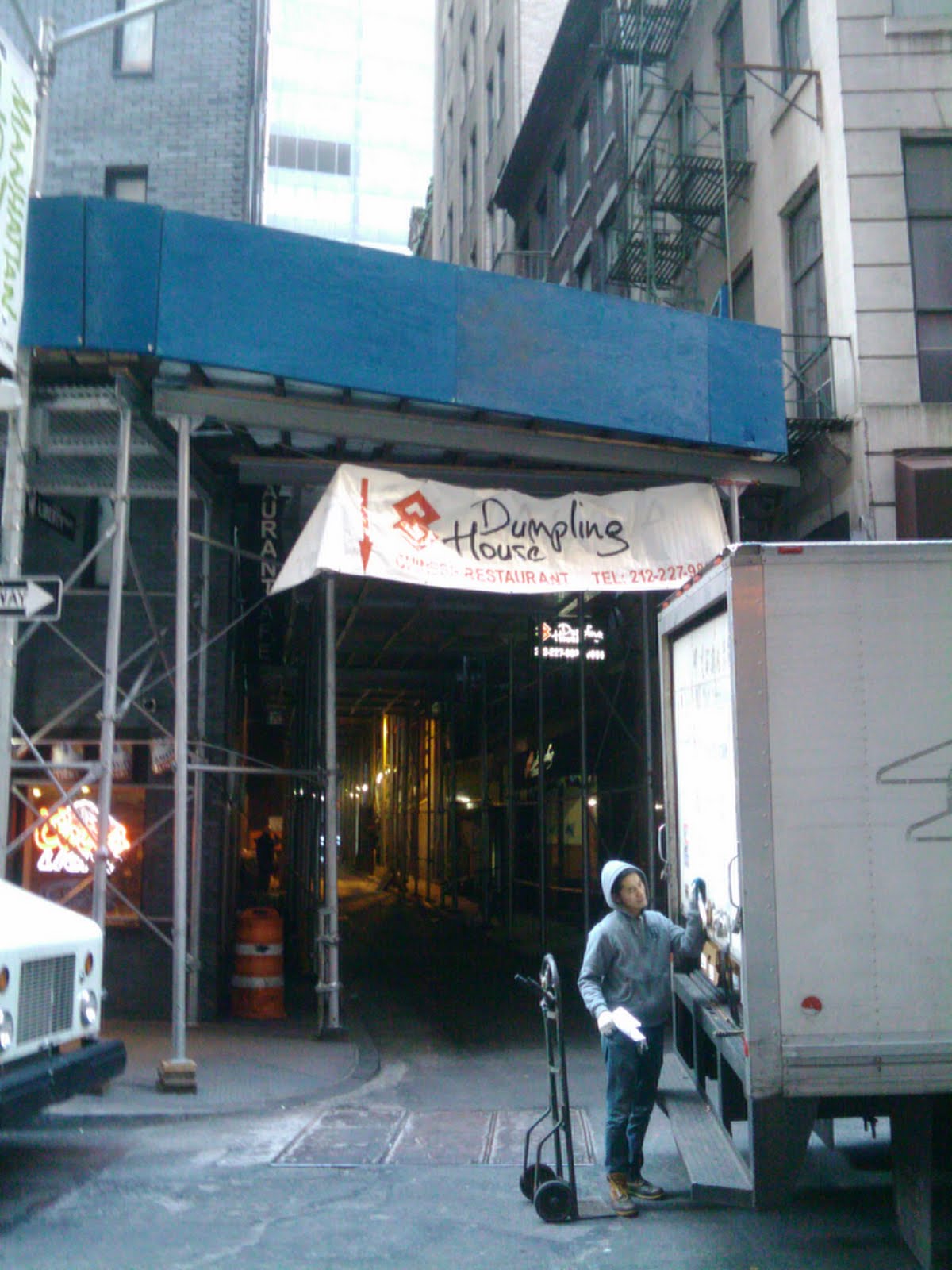
Note that Liberty Place is covered with ugly scaffolding. So is Catherine Lane:

It seems to be almost entirely used as a driveway for that parking garage.


Cortlandt Alley is definitely used as an alley for motor vehicle access. Nate Berg has a great interview with Nick Carr of the Scouting Report about Cortlandt Alley's film career:
The big thing I always get asked to find are dank dilapidated alleys, and New York City has, like, 5 alleys that look like that. Maybe four. You can’t film in three of them. So what it comes down to is there’s one alley left in New York, Cortlandt Alley, that everybody films in because it’s the last place. I try to stress to these directors in a polite way that New York is not a city of alleys.
It seems like it would be possible, maybe with some zoning changes, for some foresighted developer to take one of these streets, open a bunch of vibrant storefronts and market the hell out of it so that every tourist stops there for shopping and street food after they visit Ground Zero. It might take a year or two, but I could see one of them becoming New York's answer to Bearskin Neck or the Rue Sous le Cap. In Strong Towns terms, think how much tax revenue the city would get from such a tiny amount of infrastructure.
Tuesday, January 3, 2012
In praise of Really Narrow Streets
Lately I've been following posts by the Old Urbanist and one of his main inspirations, Nathan Lewis. Lewis puts aside political issues of compromise with car boosters and examines the question of how we would want our environment to look if we weren't planning for cars. He looks at pedestrian-oriented cities around the world and highlights examples of good design. One concept he refers to again and again is the Really Narrow Street.
These streets were usually created before cars were invented, and they have no place for cars. Some are too narrow for any car. Most are wide enough for one car to pass, but not much wider. There are examples from every continent, including Europe, Africa, Asia and South America.
In North America we have a few of these streets in some of our older towns. Here is one of the oldest, Acoma (established ca. 1300):

Here is Santo Domingo (1496):

Quebec (1608):

Boston (1630):

Albuquerque (1706):

One of my favorites, in part because it's a small town, is Rockport, Massachussetts (1743):

I spent an enjoyable few days in Rockport last summer. The street in this picture, Bearskin Neck, leads to the main docks and was a key route during the town's heyday as a fishing port. It now leads to the departure docks for some tourist boats, but is more of a destination in itself, and is lined with shops and restaurants. It functions essentially as a woonerf.
Notice that none of the streets above were laid out after 1800. Lewis attributes this to an American fad he calls "nineteenth-century hypertrophism," where wide streets became a symbol of progress and wealth. He observes that in his hometown of New Berlin, New York, the main street was designed so that you could turn a horse and carriage around in it, even though that wasn't necessary for any social purpose.
Lewis argues that Really Narrow Streets privilege the pedestrian and create an opportunity for intense commerce that cannot be matched by any street wide enough to handle cars and pedestrians together. This is an experience that shopping malls, cruise ships and theme parks are designed to replicate.
At this point you may be saying to yourself, "We tried pedestrian streets in the seventies, and many cities are allowing cars back in, because it killed the street." One answer to that is that the streets were still "hypertrophic," too wide to feel comfortable with just pedestrians. My main answer is that it was the subsidies to sprawl commerce that killed downtown streets. Many of them would probably have done just fine as pedestrian streets if the government hadn't been simultaneously building big competing highways and parking lots on the edge of town. Some of them have done fine.
These streets were usually created before cars were invented, and they have no place for cars. Some are too narrow for any car. Most are wide enough for one car to pass, but not much wider. There are examples from every continent, including Europe, Africa, Asia and South America.
In North America we have a few of these streets in some of our older towns. Here is one of the oldest, Acoma (established ca. 1300):
Here is Santo Domingo (1496):
Quebec (1608):

Boston (1630):
Albuquerque (1706):
One of my favorites, in part because it's a small town, is Rockport, Massachussetts (1743):
I spent an enjoyable few days in Rockport last summer. The street in this picture, Bearskin Neck, leads to the main docks and was a key route during the town's heyday as a fishing port. It now leads to the departure docks for some tourist boats, but is more of a destination in itself, and is lined with shops and restaurants. It functions essentially as a woonerf.
Notice that none of the streets above were laid out after 1800. Lewis attributes this to an American fad he calls "nineteenth-century hypertrophism," where wide streets became a symbol of progress and wealth. He observes that in his hometown of New Berlin, New York, the main street was designed so that you could turn a horse and carriage around in it, even though that wasn't necessary for any social purpose.
Lewis argues that Really Narrow Streets privilege the pedestrian and create an opportunity for intense commerce that cannot be matched by any street wide enough to handle cars and pedestrians together. This is an experience that shopping malls, cruise ships and theme parks are designed to replicate.
At this point you may be saying to yourself, "We tried pedestrian streets in the seventies, and many cities are allowing cars back in, because it killed the street." One answer to that is that the streets were still "hypertrophic," too wide to feel comfortable with just pedestrians. My main answer is that it was the subsidies to sprawl commerce that killed downtown streets. Many of them would probably have done just fine as pedestrian streets if the government hadn't been simultaneously building big competing highways and parking lots on the edge of town. Some of them have done fine.
Monday, January 2, 2012
The NYSAC is not your friend
You may remember the New York State Association of Counties. Last February their transportation committee passed a resolution opposing complete streets legislation, and I observed that they, like the American Association of State Highway and Transportation Officials (AASHTO) and the Governors Highway Safety Association (GHSA), constitute a lobbying organization protecting the interests of bureaucrats while pretending to be a governmental entity.
This week, Alan Chartock interviewed the Executive Director of NYSAC, Stephen Acquario. Chartock is pretty honest with his guests, but even he couldn't come right out and ask, "Where the fuck do you get off pretending that you represent the people?" if he wanted the guy to ever come back. Chartock is right to interview Acquario, because to my unending frustration, some people actually take this gang seriously.
The United States Senate and other one-state-one-vote organizations like AASHTO and the GHSA are pretty obviously unrepresentative, but the NYSAC goes so far beyond that level that I feel it's worth spending a post on. In case you weren't aware, here are some figures about New York State's counties.
The most populous county in New York, Kings (i.e. Brooklyn), contains almost 13 percent of the total population of the state, according to the 2010 Census. The five boroughs of New York City together contain 42% of the state's population, and the other five most populous counties (Suffolk, Nassau, Westchester, Erie (Buffalo) and Monroe (Rochester)) contain 28%. Under a system of one person one vote, these ten counties would control 70% of the votes, and the other 52 counties would be irrelevant.
Instead, the NYSAC operates by a system of one county, one vote, which means that the representatives of the 70% of the population who live in the ten most populous counties only have 16% of the votes. The ten least populous counties (Hamilton, Schuyler, Yates, Lewis, Schoharie, Seneca, Essex, Wyoming, Orleans and Delaware), with their combined share of 1.63% of the population, control an equal 16% of the votes.
The NYSAC's Transportation and Public Works Committee, which passed the resolution, is similarly lopsided. It is chaired by Jean Raymond, the Supervisor of the Town of Edinburg, NY (population 1,384), which has no buses, no trains and no sidewalks. The co-chair is Randy Gibbon, the Director of Public Works for Chenango County (population 50,477), which actually contains New Berlin, the home of Nathan Lewis (and here's what Lewis has to say about streets). Also on the committee is Andra Horsch, chief lobbyist for the New York City Department of Transportation, but it's not clear whether she gets five votes or one.
Somehow Monroe County (3.8% of the population), Broome (1.0%), Livingston (0.34%) and Wyoming County (0.22%) each have two seats on the Committee. Maybe they have one representative for transportation and one for public works, or one for the legislature and one for the county executive, but I can't tell if they get two votes. Regardless, I'm pretty sure that the NYC, Erie and Monroe County representatives (with more than half of the state's population) don't outweigh the other 19 committee members.
I hope I've established by now how lopsided this organization is. Now back to Stephen Acquario and his interview with Alan Chartock. This year, Chartock has been asking all his guests the same question about party control of the New York State Senate. Here are the statewide political party enrollments as of November 1 (PDF):
With the Democrats just shy of a majority of registered voters and the Republicans only claiming a quarter of them, it's pretty obvious that the State Senate will not stay in Republican hands without a bunch of dirty tricks. Acquario said that it was in "the counties"' interest for the Senate to stay in Republican control, because a Senate controlled by Democrats would be dominated by senators from New York City who won't pay any attention to the needs of "counties."
It seems pretty clear to me that the needs of "counties" shouldn't matter. Counties aren't people. They contain people, and we do need basic safeguards to prevent urban majorities from running roughshod over country dwellers, but giving residents of sparsely populated areas an overrepresentation in government is a really bad way to do that.
If you have any doubt about the representativeness of the NYSAC, consider this final point. The official name of the dominant party is the "New York State Democratic Committee." Longstanding usage is that things associated with the party will be referred to with the adjective "Democratic" with a capital D, as in "the Democratic Party" and "Democratic control." Several times in the interview, Acquario referred to these things as "the Democrat Party," "Democrat control" and so forth. This is a well-documented insult to the Democrats that has been used by Republicans for generations, and it is never used unintentionally. It's been called "fighting words."
I do not take that insult personally, because I'm not a Democrat either and I have no love for the party that killed bridge tolls. However, it's a clear signal that Acquario is a Republican partisan who sees the Democratic party as an enemy. It shows, unequivocally, that he has no interest in representing the needs of Democrats or city dwellers. By using it, Acquario has exposed the New York State Association of Counties as a tool for rural Republicans to attack urban interests.
It is clear that Andrea Horsch and the other representatives of populous counties in New York State are wasting their time participating in this sham organization. There are better ways of ensuring the protection of the people who live in rural parts of the state. I suggest that we put their time to better use and withdraw from the NYSAC any basis for their pretense of legitimacy.
This week, Alan Chartock interviewed the Executive Director of NYSAC, Stephen Acquario. Chartock is pretty honest with his guests, but even he couldn't come right out and ask, "Where the fuck do you get off pretending that you represent the people?" if he wanted the guy to ever come back. Chartock is right to interview Acquario, because to my unending frustration, some people actually take this gang seriously.
The United States Senate and other one-state-one-vote organizations like AASHTO and the GHSA are pretty obviously unrepresentative, but the NYSAC goes so far beyond that level that I feel it's worth spending a post on. In case you weren't aware, here are some figures about New York State's counties.
The most populous county in New York, Kings (i.e. Brooklyn), contains almost 13 percent of the total population of the state, according to the 2010 Census. The five boroughs of New York City together contain 42% of the state's population, and the other five most populous counties (Suffolk, Nassau, Westchester, Erie (Buffalo) and Monroe (Rochester)) contain 28%. Under a system of one person one vote, these ten counties would control 70% of the votes, and the other 52 counties would be irrelevant.
Instead, the NYSAC operates by a system of one county, one vote, which means that the representatives of the 70% of the population who live in the ten most populous counties only have 16% of the votes. The ten least populous counties (Hamilton, Schuyler, Yates, Lewis, Schoharie, Seneca, Essex, Wyoming, Orleans and Delaware), with their combined share of 1.63% of the population, control an equal 16% of the votes.
The NYSAC's Transportation and Public Works Committee, which passed the resolution, is similarly lopsided. It is chaired by Jean Raymond, the Supervisor of the Town of Edinburg, NY (population 1,384), which has no buses, no trains and no sidewalks. The co-chair is Randy Gibbon, the Director of Public Works for Chenango County (population 50,477), which actually contains New Berlin, the home of Nathan Lewis (and here's what Lewis has to say about streets). Also on the committee is Andra Horsch, chief lobbyist for the New York City Department of Transportation, but it's not clear whether she gets five votes or one.
Somehow Monroe County (3.8% of the population), Broome (1.0%), Livingston (0.34%) and Wyoming County (0.22%) each have two seats on the Committee. Maybe they have one representative for transportation and one for public works, or one for the legislature and one for the county executive, but I can't tell if they get two votes. Regardless, I'm pretty sure that the NYC, Erie and Monroe County representatives (with more than half of the state's population) don't outweigh the other 19 committee members.
I hope I've established by now how lopsided this organization is. Now back to Stephen Acquario and his interview with Alan Chartock. This year, Chartock has been asking all his guests the same question about party control of the New York State Senate. Here are the statewide political party enrollments as of November 1 (PDF):
| Democratic | 5,660,246 | 49% |
| Republican | 2,824,680 | 25% |
| Conservative | 147,993 | 1.3% |
| Working Families | 42,776 | 0.37% |
| Independence | 434,752 | 3.8% |
| Green | 21,095 | 0.18% |
| Other | 3,351 | 0.029% |
| Blank | 2,326,786 | 20% |
| Total | 11,461,679 |
With the Democrats just shy of a majority of registered voters and the Republicans only claiming a quarter of them, it's pretty obvious that the State Senate will not stay in Republican hands without a bunch of dirty tricks. Acquario said that it was in "the counties"' interest for the Senate to stay in Republican control, because a Senate controlled by Democrats would be dominated by senators from New York City who won't pay any attention to the needs of "counties."
It seems pretty clear to me that the needs of "counties" shouldn't matter. Counties aren't people. They contain people, and we do need basic safeguards to prevent urban majorities from running roughshod over country dwellers, but giving residents of sparsely populated areas an overrepresentation in government is a really bad way to do that.
If you have any doubt about the representativeness of the NYSAC, consider this final point. The official name of the dominant party is the "New York State Democratic Committee." Longstanding usage is that things associated with the party will be referred to with the adjective "Democratic" with a capital D, as in "the Democratic Party" and "Democratic control." Several times in the interview, Acquario referred to these things as "the Democrat Party," "Democrat control" and so forth. This is a well-documented insult to the Democrats that has been used by Republicans for generations, and it is never used unintentionally. It's been called "fighting words."
I do not take that insult personally, because I'm not a Democrat either and I have no love for the party that killed bridge tolls. However, it's a clear signal that Acquario is a Republican partisan who sees the Democratic party as an enemy. It shows, unequivocally, that he has no interest in representing the needs of Democrats or city dwellers. By using it, Acquario has exposed the New York State Association of Counties as a tool for rural Republicans to attack urban interests.
It is clear that Andrea Horsch and the other representatives of populous counties in New York State are wasting their time participating in this sham organization. There are better ways of ensuring the protection of the people who live in rural parts of the state. I suggest that we put their time to better use and withdraw from the NYSAC any basis for their pretense of legitimacy.
Subscribe to:
Posts (Atom)